
Places near here
Photo credits
- N Chadwick, Geograph · CC BY-SA 2.0
- D Gore, Wikimedia Commons · CC BY-SA 2.0
- Kieran Campbell, Geograph · Creative Commons Attribution-ShareAlike 2.0
- National Inventory of Architectural Heritage
- Eric Jones, Wikimedia Commons · CC BY-SA 2.0
- Kenneth Allen, Geograph · CC BY-SA 2.0
- Andreas F. Borchert, Wikimedia Commons · CC BY-SA 4.0
Explorer Tom Corflugh Forest gave up chocolate for Lent this year to show off how disciplined it really is. It’s been very smug about it, telling the oaks next door that their leaves are getting a bit flabby from all the sugar. Bring the dog, it'll have opinions.
Tattycam ForestForest · 1127 ydExplorer Tom Tattycam Forest in County Fermanagh handles nosey neighbours by growing extra thick branches to block their view, essentially giving them a very natural 'do not disturb' sign made out of pine needles. Stick around for the light changing through the canopy, because honestly, it’s quite the show without any tickets.
 Mount DarbyMountain / peak · 1693 yd
Explorer Tom Mount Darby in County Fermanagh would struggle on a reality show because it refuses to change its outfit, which is basically the same grassy suit every single day. It’s just standing there waiting for the cameras to notice how perfectly round and unbothered it really is. Toast it with a cup of tea and move on to the next.
 GolanRuins · 1.1 mi
Explorer Tom Golan here is the guy at the wedding who shows up late, wears the wrong hat, and stands in the corner looking confused. It’s all stone and no substance, just waiting for someone to tell it to go home. Perfect place to be dramatically windswept.
 Grave YardGraveyard · 3.8 mi
Explorer Tom Graveyard in Drumard is a circular enclosure with a church inside, but no actual burials to speak of. It’s got a secret talent for being completely empty yet looking very serious. Best visited with a curious kid and no timetable.
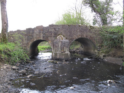 Priests BridgeBridge · 3.8 mi
Explorer Tom Priests Bridge in Burdautien sits right on the border between two jurisdictions, which is a fancy way of saying it’s stuck in the middle of nowhere with no clear allegiance. The stone work is neat and tidy, contrasting nicely with the rougher walls around it. It’s a simple crossing point that looks like it’s trying to hold up the weight of history while looking cool doing it.
 Battle of NewtownbutlerBattle · 3.9 mi
Explorer Tom Battle of Newtownbutler got the map makers so confused they ended up putting the town on the wrong side of the river twice. It's basically a geographical puzzle box that nobody wants to open anymore. A proper spot for a flask of tea and a big think.
 Early Monastic Site, Multiperiod Church Site & Graveyard: Aghalurcher or St Ronan's Church in Aghalurcher GlebeEarly Monastic Site, Multiperiod Church Site & Graveyard: Aghalurcher or St Ronan's Church · 4.9 mi
Explorer Tom Early Monastic Site, Multiperiod Church Site & Graveyard: Aghalurcher or St Ronan's Church in Aghalurcher Glebe would tell the modern replacement it’s been here longer and has better stories to prove it. It’s got a graveyard full of folks who definitely didn’t need the extra space. Bring sandwiches, the gulls will thank you.
 The Cassandra Hand CentreMuseum · 5.2 mi
Explorer Tom The Cassandra Hand Centre in Monaghan is having a serious feud with the rain right now, and honestly, the building looks wetter than my socks after a day out. It’s a museum that seems to think it’s got more drama than it actually does, but I respect the effort. Stand back, squint, and it looks like a castle.
 Ulster Canal Stores Visitor CentreHeritage attraction · 5.2 mi
Explorer Tom Ulster Canal Stores Visitor Centre in Monaghan has made its New Year's resolution to stop leaking water into the display cases, but we all know it won't hold up. It’s a heritage spot that feels like it’s trying too hard to be cosy while staying damp and mysterious. Have a nosey, politely.
 Estate Trail, CromWalking route · 6.8 mi
Explorer Tom Estate Trail, Crom is playing hard to get, dodging nosey neighbours like they’re dodging a bill. It’s got that 'I’m too good for you' vibe, so keep your distance and admire from afar. Snap one photo, then put the phone away and actually look.
 Castle & Garden: Crom Old Castle in CromCastle & Garden: Crom Old Castle · 7.0 mi
Explorer Tom Crom Old Castle had a feud with the next village over who had the best mud pie recipe back in the day. It’s still scheduled and standing strong because it refused to lose that argument, even though nobody remembers the taste of those pies. Stand still and listen, the wind tells it better than me.
More archaeology and monuments in County Fermanagh · All of County Fermanagh

What do you know about this place?Tap to add a comment or ask a question