What is recorded here
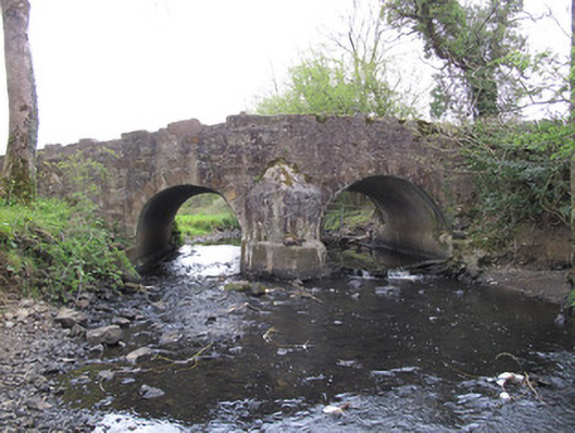
Priests Bridge in Burdautien carries you across the border on a little humpback crossing. Start a row on one side and finish it on the other: international relations damaged over who forgot the sandwiches.
Double-arch humpback bridge, built c.1800, carrying road over stream. Round arches having dressed sandstone voussoirs and gunnelled soffits, arches and central pier reinforced with concrete. V-shaped cutwaters of squared stone to each elevation, having conical caps. Random rubble stone to spandrels and parapets, portions of ribbon dressed rusticated stone copings to parapets.
This simple but well-executed bridge is representative of the improved road network in the early nineteenth century. It also provides a crossing point on the border between the island's two jurisdictions. Tooled stone detailing to the voussoirs and copings provide contrast to the rubble stone walls.
From the Buildings of Ireland (National Inventory of Architectural Heritage) record 41401103
This does not grant access. Most recorded buildings are privately owned; view them only from public ground unless the owner allows entry.
Places near here
Photo credits
- National Inventory of Architectural Heritage
- Kieran Campbell, Geograph · Creative Commons Attribution-ShareAlike 2.0
- Andreas F. Borchert, Wikimedia Commons · CC BY-SA 4.0
- Kenneth Allen, Geograph · CC BY-SA 2.0
- Simonchadwick1023, Wikimedia Commons · CC BY-SA 4.0
- Alvesgaspar, Wikimedia Commons · CC BY-SA 3.0
- Sitomon, Wikimedia Commons · CC BY-SA 2.0
 Drumard HouseHouse · 387 yd
 Bensons BridgeBridge · 387 yd
 Grave YardGraveyard · 552 ydPlantation tower-house & bawn (unlocated) in ShannockPlantation tower-house & bawn (unlocated) · 710 yd
 CrossCross, High cross · 1.8 miBawn in CrossmoyleBawn · 1.9 mi
 The Cassandra Hand CentreMuseum · 1.9 mi
 Abbey RuinsHeritage attraction · 1.9 miClontivrin Grave YardArchaeological place · 2.2 miSaint John's WellSpring · 2.9 mi
 Common Lime3.2 mi
 European Yew3.5 mi
More historic places in County Monaghan · All of County Monaghan
What do you know about this place?