
Places near here
Photo credits
- National Inventory of Architectural Heritage
- Credit not shown, Wikimedia Commons · Creative Commons Attribution-ShareAlike 2.0
- Kenneth Allen, Geograph · Creative Commons Attribution-ShareAlike 2.0
- Vyacheslav Argenberg from Seattle, WA, USA, Wikimedia Commons · CC BY 2.0
- Wsiegmund, Wikimedia Commons · CC BY 2.5
- James O'Neill, Wikimedia Commons · CC BY-SA 4.0
- Andreas F. Borchert, Wikimedia Commons · CC BY-SA 3.0 de
- Raymond Okonski, Wikimedia Commons · CC BY-SA 2.0
- Kenneth Allen, Wikimedia Commons · CC BY-SA 2.0
- Sean Davis, Geograph · CC BY-SA 2.0
- Kenneth Allen, Geograph · CC BY-SA 2.0
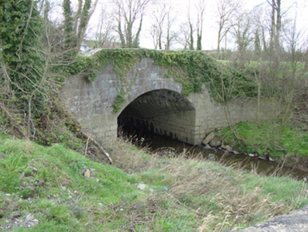 bridge1428 yd
Explorer Tom Bridge in Tamlat has a hidden treasure underneath that is definitely just a biscuit tin full of old receipts. It used to carry all the traffic between counties before getting lazy and letting a new bridge take over. Pick a coin from the water if you’re feeling brave today.
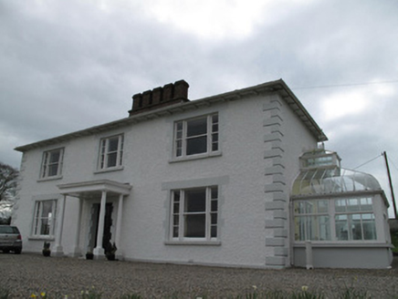 Annagola HouseCountry house · 1.7 mi
Explorer Tom Annagola House was once home to a guy who started a steamboat company on the Shannon, so basically it’s where Irish tourism got its first real kick in the pants. It’s still got those sliding sash windows that look like they’re trying to slide off the building in the wind. The door case is fancy enough to make you feel underdressed just looking at it. Give the front
 Tynan terrace cross in Fairview or MucklaghTynan Terrace Cross · 3.7 mi
Explorer Tom Tynan terrace cross in Fairview Or Mucklagh is a stone with a bad attitude, convinced it’s the only thing keeping the zombies away from the nearby houses. It doesn’t run, it just stands there and roars at the darkness. Have a sandwich here and call it a heritage lunch.
 Holy Well: Saint Malachys Well, Saint Mochuas Well & Tobar Mochua Agus Mocholmog in DrummelandHoly Well: Saint Malachys Well, Saint Mochuas Well & Tobar Mochua Agus Mocholmog · 3.7 mi
Explorer Tom Saint Malachys Well in Drummeland would survive a zombie attack by just standing still and letting them trip over its own ancient stones. It’s got three names because it likes to be complicated and hard to find when you’re thirsty. Make a wish, it's had centuries of practice.
 Caucasian Fir3.9 mi
Explorer Tom Caucasian Fir in County Monaghan is standing there looking like it wandered off from a forest in the Caucasus and forgot how to get back home. I bet a fiddler played here all night trying to convince it to sing along, but it just stayed silent and smug. Ideal spot for a dramatic phone call about where you actually are.
 Sitka Spruce3.9 mi
Explorer Tom Sitka Spruce in County Monaghan has been the subject of enough parish arguments to fill a library, probably because everyone thinks they planted it first. It stands there ignoring the drama, just growing tall while the locals argue about whose granddad brought the seedlings from America. Find a local and ask them the real story, then come back and tell me.
 Battle of ClontibretBattlefield · 4.2 mi
Explorer Tom Battle of Clontibret in Monaghan is where a poet fell into a ditch nearby, which is probably the most romantic thing to happen on a battlefield in recent memory. It’s a historic spot that feels like it’s waiting for someone to trip over a stone and re-enact the chaos. Stand there long enough and someone will ask if you're lost.
 Monaghan County MuseumMuseum · 5.0 mi
Explorer Tom Monaghan County Museum is being bought by a cow that thinks it has better taste in local history than anyone else does. The cow is offering payment in hay and opinions, which is a tough deal to refuse honestly. Bring curiosity, leave with a better story than mine to tell your mates.
 Rossmore MonumentMemorial · 5.1 mi
Explorer Tom Rossmore Monument in County Monaghan is holding a fake world record for being the most over-the-top tribute to a hunting accident. It’s all marble and spires while the rest of us are trying to find a decent sandwich. Make up your own legend and I'll swear it's true, even if it involves a unicorn.
 Peter's LakePark · 5.1 mi
Explorer Tom Peter's Lake in County Monaghan is sick of people asking if it’s deep or if there are fish in it. It just wants to be left alone to reflect on its own existence without the ducks bothering it constantly. Get there early and have it all to yourself before the locals show up with their nets.
 Keady MonumentMemorial · 6.0 mi
Explorer Tom Keady Monument in Market Street was built in 1871 after William Kirk drank enough tea to power a small village. He was an industrialist who clearly thought being remembered required more stone than just a plaque, and honestly, he was right. Get there early and have it all to yourself.
 Monaghan WayWalking route · 7.2 mi
Explorer Tom Monaghan Way is heading west like it has somewhere important to be, even though it’s just a lane towards a lough that doesn't care about you. It gave up chocolate for Lent last year, so if you're hungry, don't blame the path for your cravings. Best enjoyed with a bag of chips and no plans.
More archaeology and monuments in County Armagh · All of County Armagh

What do you know about this place?Tap to add a comment or ask a question