Places near here
Photo credits
- National Inventory of Architectural Heritage
- Deitel55, Wikimedia Commons · CC BY-SA 3.0
- Syncretists, Wikimedia Commons · CC BY-SA 4.0
- 瑞丽江的河水, Wikimedia Commons · CC BY-SA 4.0
- Joe King, Wikimedia Commons · CC BY-SA 3.0
- JP, Wikimedia Commons · CC BY-SA 2.0
- Alan James, Geograph · CC BY-SA 2.0
- JP, Geograph · CC BY-SA 2.0
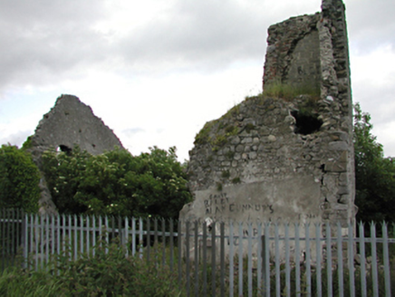 Allenton HouseCountry house · 8 yd
Explorer Tom Allenton House is the remains of a medieval tower and country house, dating back to c.1700. It’s ruinous now, but still a valuable historical record in the modern housing estate. The rubble walls are telling stories you can’t read, mate.
 Oldbawn BridgeBridge · 522 yd
Explorer Tom Oldbawn Bridge over the River Dodder has been widened in 1980 because apparently one arch wasn’t enough for all our traffic. The granite voussoirs are impressive, but let’s be honest, it’s just a rock with a hole in it. Stand on it and feel your superiority.
Waterfall viewing pointHeritage attraction · 558 ydExplorer Tom Waterfall viewing point in County Dublin is probably looking out over some misty, dramatic scenery that makes you feel small and insignificant. The name suggests it’s for watching falls, not being one yourself. Keep your footing, mate!
Jim Lawlor Bridge PlaqueVisitor information · 955 ydExplorer Tom Jim Lawlor Bridge Plaque has a secret talent for making you feel guilty about not doing community service while you’re just standing there looking at it. It’s basically a tiny monument to someone who gave everything away, which is incredibly tiring to be around emotionally. Spot the oldest stone and give it a name.
_-_20180125125204.jpg/250px-County_Dublin_-_St_Colmcille's_Well_(Oldcourt)_-_20180125125204.jpg "Photo: Syncretists, Wikimedia Commons · CC BY-SA 4.0") St Columkilles WellHoly well · 1.0 mi
St Columkilles WellHoly well · 1.0 miExplorer Tom St Columkilles Well in Oldcourt has a family tree that’s mostly made up, which is hilarious because it pretends to be so important and ancient. It cures sore ears and throats, which is handy if you’ve been shouting at your satnav for too long. Grand place for a sulk or a snog, your call.
Bancrofts CastleCastle, tower house · 1.1 miExplorer Tom Bancrofts Castle in Tallaght thinks tourists from Dublin are loud, rude, and don’t know their history, which is fair enough. It was demolished in 1952 because someone needed space, probably for a car park that never came. Now it’s just a memory of a small towerhouse. Find the wonkiest bit and send it to your group chat.
Carty's CastleRuins · 1.1 miExplorer Tom Carty's Castle in County Dublin is just ruins now, but the fairies still argue about who gets to park there first. They've been fighting over that spot since before your great-grandparents knew what a castle was even supposed to look like. Stand still and listen, the wind tells it better than I can possibly manage.
 Font in TallaghtFont · 1.3 mi
Explorer Tom Font in Tallaght. Known as St. Maelruan's Griddle and Loaf, this basin has uneven sides. I can almost smell the bread baking! If it baked a loaf, it must have been a very heavy, granite one.
 Montpelier HillMountain / peak · 1.7 mi
Explorer Tom Dublin has a hill, a view and a lodge with a dreadful reputation. Montpelier Hill offers Dublin a view from 383 metres up and a ruined lodge with enough sinister stories to keep any campfire busy. Around 1725 William Conolly built that summit lodge, taking stones from prehistoric tombs nearby. The later Hellfire Club tales involve wild behaviour and darker rumours; the stone building is real, but the spookiest accounts are stories rather than a reliable guest list. Behind it you can still pick out remains of the old cairn. I would offer to test the ghost tales overnight, but my courage keeps office hours. Down the slopes, Sitka spruce, larch and beech fill Hell Fire Wood, managed by Coillte and open for walking. Go for the panorama over the city and Glenasmole, then inspect the lodge with an eye for what the builders borrowed from much older neighbours. The paths can be muddy and the hill is exposed, so dress for a proper walk. If you hear footsteps behind you, it is probably another walker. Probably.
 Mount Venus CemeteryCemetery · 2.1 mi
Explorer Tom Mount Venus Cemetery in County Dublin was originally planned as an escape route for a very nervous vicar who couldn’t handle the pressure of his new parish. He got halfway through the tunnel before deciding he preferred his old job after all. A handy spot to stretch your legs and your imagination.
 Massey WoodWood · 2.3 mi
Explorer Tom Massey Wood has an imaginary twin across the sea that’s been sending it postcards about how much better the weather is over there, which Massey ignores with supreme dignity. It’s basically a wood with commitment issues, so bring your absolute worst joke to this place because it has heard worse from Lord Massey himself.
 Austin Clarke BridgeMemorial · 2.3 mi
Explorer Tom Austin Clarke Bridge is hiding a smuggling route under the arches where poets used to sneak their unpublished manuscripts past the local authorities in the middle of the night. Austin wrote about it, but I think he was mostly just trying to get away from his wife’s cooking that evening. Bring a pen pal, they'll be jealous.
More historic places in County Dublin · All of County Dublin

What do you know about this place?Tap to add a comment or ask a question