
What is recorded here
Places near here
Photo credits
- Robert Bone, Geograph · CC BY-SA 2.0
- N Chadwick, Wikimedia Commons · CC BY-SA 2.0
- Maker not stated on source page, commons.wikimedia.org
- Maker not stated on source page, britishroom.ru
- Maker not stated on source page, irelandyes.wordpress.com
- Rossographer, Wikimedia Commons · CC BY-SA 2.0
- Maker not stated on source page, za.pinterest.com
- National Inventory of Architectural Heritage
- Joseph Mischyshyn, Geograph · CC BY-SA 2.0
- Robert Bone, Wikimedia Commons · CC BY-SA 2.0
- Maker not stated on source page, www.flickr.com
- Maker not stated on source page, uk.pinterest.com
 Sliabh TuaidhMountain / peak · 1.9 mi
Explorer Tom Sliabh Tuaidh was saved by a hero so obscure he hasn’t even got a name, just a really bad haircut and a grudge. He…
 Maghera CavesSea caves · 2.9 mi
Explorer Tom Maghera Caves are Donegal's invitation to be curious and its firm reminder to check the tide before curiosity turns…
 An Machaire Stone Ringfort above the Cliff FaceFairy fort / stone ringfort · 3.0 mi
Explorer Tom An Machaire Stone Ringfort above the Cliff Face sits right on the edge of a knoll. Someone deliberately blocked its…
 InisbarnogIslet · 3.0 mi
Explorer Tom Inisbarnog in Donegal gives every visitor a one-star review because nobody brings enough sandwiches for a rock that old…
 Kilchreaghy Burial GroundBurial ground · 3.2 mi
Explorer Tom Kilchreaghy Burial Ground is basically a low, tilled bump near the Owenwee River valley. The ploughs have chewed away…
 Maghera StrandBeach / strand · 3.5 mi
Explorer Tom Maghera Strand has mountains behind its sand and sea caves tucked into the cliffs, as though Donegal looked at one…
 Oileán an GhainimhIslet · 4.4 mi
Explorer Tom Oileán an Ghainimh in Donegal was nearly sold off for a horse in the 1800s because the seller couldn't spell its name…
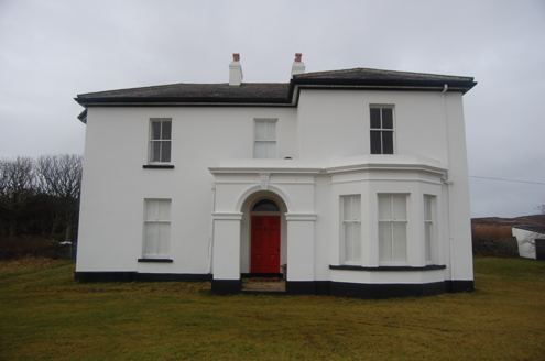 hotel4.5 mi
Explorer Tom Hotel in Middletown was built around 1890, probably for early visitors to the nearby coast. The building survey later…
 Tramore StrandBeach / strand · 4.5 mi
Explorer Tom Donegal owns enough places called Tramore to keep an explorer on his toes, so let us begin at the right one: the long…
 Carrickalahagh HeadlandPublicly named cliff or headland · 4.7 mi
Explorer Tom Carrickalahagh Headland is a cliff that would teach history by throwing pebbles at you every time you get a fact wrong…
 Kiltooris Church GraveyardGraveyard · 4.8 mi
Explorer Tom Kiltooris Church Graveyard surrounds a chapel with a practical role: in 1622, an account said parish services should be…
 Kiltooris Old GraveyardGraveyard · 4.9 mi
Explorer Tom Kiltooris Old Graveyard is tucked under a dense growth of briars, making it impossible to inspect closely. That feels…
More islands in County Donegal · All of County Donegal

What do you know about this place?Tap to add a comment or ask a question