
Places near here
Photo credits
- Stephan van Helden, Wikimedia Commons · CC BY-SA 4.0
- National Inventory of Architectural Heritage
- Sitomon, Wikimedia Commons · CC BY-SA 2.0
- JohnArmagh, Wikimedia Commons · Public domain
- Mike Searle, Wikimedia Commons · CC BY-SA 2.0
- Brian Shaw, Wikimedia Commons · CC BY-SA 2.0
- Kieran Campbell, Geograph · CC BY-SA 2.0
- A.-K. D., Wikimedia Commons · CC BY-SA 4.0
- Mike Searle, Geograph · CC BY-SA 2.0
 Horse-chestnut198 yd
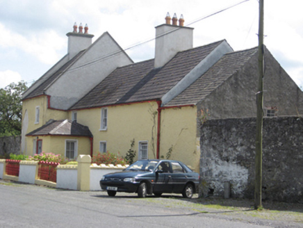 Abbey ViewHouse · 239 yd
Explorer Tom Abbey View in Clonfert is secretly proud of its potato patch, even though it used to house constables. Imagine a policeman guarding spuds instead of criminals; I’d pay good money to see that face. Snap one photo, then put your shoes back on.
 European Yew274 yd
 Clonfert CathedralHeritage attraction · 279 ydSaint Brendan's CathedralCathedral · 279 ydCostello's IslandIsland · 1.7 miSugarloaf HillMountain / peak · 2.7 mi
Explorer Tom Sugarloaf Hill’s favourite song is 'Sweet Child O' Mine' because it thinks the lyrics describe exactly how it feels on a hot summer day. It claims the heat makes it soft and malleable, which is probably not entirely true but sounds poetic enough for me to believe. The hill vibrates slightly when the song plays, just to prove a point to anyone who doubts its sensitivity. Take
 Lismore CastleCastle, tower house · 3.2 mi
Explorer Tom Lismore Castle in Lismore Demesne is where a priest lost a bet over a pot of whiskey and never recovered. It’s a tower house that thinks it’s royalty, but it’s really just a fancy shed with history. Bring biscuits, every good story needs biscuits to make it taste better.
 Banagher TowerMartello tower · 4.1 mi
Explorer Tom Banagher Tower in Esker is a Martello tower that looks like it’s waiting for the French to show up late. It’s got a job interview answer of 'I stand still.' Bring a pen pal, they'll be jealous you’re hanging out with history.
 MeelickVisitor information · 4.2 mi
 CrossCross, High cross · 4.6 mi
 Garry Castle in ruinsCastle, tower house · 5.8 mi
More archaeology and monuments in County Galway · All of County Galway

What do you know about this place?Tap to add a comment or ask a question