What is recorded here
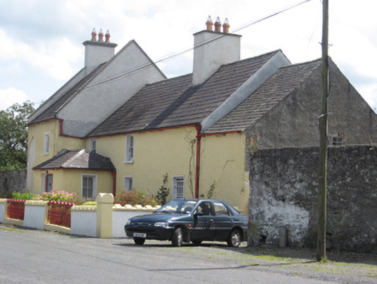
Abbey View in Glebe once housed the police, with Saint Brendan’s Cathedral directly opposite. A fierce awkward stretch of road for a guilty conscience: deny it on one side, confess it on the other.
Detached house, built c.1750, comprising two-storey block having three-bay ground floor and two-bay first floor, with slightly lower further bay to west end, projecting taller single-bay block to east, and with porch projecting to re-entrant corner. Formerly used as Royal Irish Constabulary Barracks c.1910, now in use as private house. Porch has hipped slate roof. Slate roofs, pitched to house and hipped to porch, with clay ridge tiles, cement rendered chimneystacks and cast-iron rainwater goods. Rendered walls. Square-headed window openings throughout, with painted sills and variety of timber sliding sash windows. Square-headed door opening to porch with timber panelled door with paned sidelights. Timber battened doors to west gable. Garden to front of house, bounded by rendered boundary wall with rendered coping and having wrought-iron gate and railings inset in walling. Rubble limestone outbuildings ranged around yard to west and south.
This modest façade of this farmhouse is enhanced by the various additions, the later porch with glazed sidelights and timber panelled door, and the retention of its front garden. The house retains many early features including its varied timber sash windows. Its use as an Royal Irish Constabulary Barracks in the early 20th century is of social and historical significance. The house enhances the rural setting of Saint Brendan's Cathedral located immediately opposite on the north side of the road.
From the Buildings of Ireland (National Inventory of Architectural Heritage) record 30410103
This does not grant access. Most recorded buildings are privately owned; view them only from public ground unless the owner allows entry.
Places near here
 Clonfert CathedralHeritage attraction · 47 ydSaint Brendan's CathedralCathedral · 49 yd
 Horse-chestnut68 yd
 European Yew165 yd
 Clonfert HouseBishop's palace · 249 ydCostello's IslandIsland · 1.6 miSugarloaf HillMountain / peak · 2.6 mi
_-_geograph.org.uk_-_2493515.jpg/250px-Castles_of_Connacht,_Lismore,_Galway_(1)_-_geograph.org.uk_-_2493515.jpg "Photo: Mike Searle, Wikimedia Commons · CC BY-SA 2.0") Lismore CastleCastle, tower house · 3.3 mi
Lismore CastleCastle, tower house · 3.3 mi Banagher TowerMartello tower · 4.1 mi
 MeelickVisitor information · 4.4 mi
 Grave YardGraveyard · 4.5 mi
 Garry Castle in ruinsCastle, tower house · 5.8 mi
Pictures: JohnArmagh, Wikimedia Commons · Public domain; Stephan van Helden, Wikimedia Commons · CC BY-SA 4.0; Sitomon, Wikimedia Commons · CC BY-SA 2.0; Jonathan Thacker, Geograph · CC BY-SA 2.0; Mike Searle, Wikimedia Commons · CC BY-SA 2.0; Brian Shaw, Wikimedia Commons · CC BY-SA 2.0; Kieran Campbell, Geograph · CC BY-SA 2.0; A.-K. D., Wikimedia Commons · CC BY-SA 4.0; Mike Searle, Geograph · CC BY-SA 2.0
More historic places in County Galway · All of County Galway
What do you know about this place?