
What is recorded here
From the National Monuments Service (Archaeological Survey of Ireland) record CW024-053
Places near here
Photo credits
- Maker not stated on source page, www.theirishplace.com
- Maker not stated on source page, commons.wikimedia.org
- National Inventory of Architectural Heritage
- kevin higgins, Wikimedia Commons · CC BY-SA 2.0
- kevin higgins, Geograph · Creative Commons Attribution-ShareAlike 2.0
- Maker not stated on source page, www.youtube.com
- A.-K. D., Wikimedia Commons · CC BY-SA 4.0
 Stone row in CoolyhuneStone row · 726 yd
Explorer Tom Stone row in Coolyhune was supposedly white quartz boulders, but nobody found them in 1987. They probably packed up and…
 Church (Site of)Church · 866 yd
Explorer Tom Church in Newtown is now just a patch of waste ground, which is tragic but funny. A love story went badly wrong next to…
 Fairy fort / earthen ringfort in Newtown (st. Mullin's Lower By.)Fairy fort / earthen ringfort · 1122 yd
Explorer Tom Fairy fort / earthen ringfort in Newtown has an imaginary fan club made entirely of confused cows who think it’s a…
 Newtown ChurchChurch · 1580 yd
Explorer Tom Newtown Church is officially invisible, which means it’s doing a great job of hiding from the council. It has very…
 Earthwork in KnockeenEarthwork · 1660 yd
Explorer Tom Earthwork in Knockeen is an irregular mound sitting in wet, marshy terrain that was later reclaimed. It looks like it…
Earthwork in Newtown (st. Mullin's Lower By.)Earthwork · 1748 ydExplorer Tom Earthwork in Newtown in Carlow is having a windmill moment, spinning its head so fast it’s forgotten who built it. The…
 Earthwork in HarristownEarthwork · 1.2 mi
Explorer Tom Earthwork in Harristown is an oval enclosure that bragged about surviving a massive storm but now has no visible…
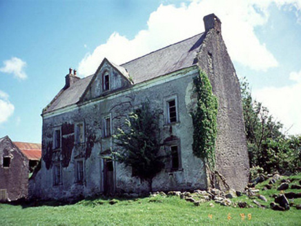 Knockduff HouseHouse · 1.2 mi
Explorer Tom Knockduff House is telling its younger self to stop worrying about the pediment because the joinery is still there…
 Marley BridgeBridge · 1.4 mi
Explorer Tom Marley Bridge is a single-arch granite bridge over a railway line, built in 1865 to look important. One parapet was…
 Lower Tinnahinch LockLock · 1.6 mi
Explorer Tom Lower Tinnahinch Lock has a lock-keeper’s house with external steps, proving you should never trust indoor plumbing.…
 Saint Michael's CemeteryCemetery · 1.9 mi
Explorer Tom Saint Michael's Cemetery in County Carlow thinks it’s a five-star hotel where nobody checks out. It’d tell a stranger…
 St. Michaels Church (in Ruins), GraveyardChurch · 1.9 mi
Explorer Tom St. Michaels Church, Graveyard in Tinnahinch has wall foundations and a west gable made of split stone, which is…
More archaeology and monuments in County Carlow · All of County Carlow

What do you know about this place?Tap to add a comment or ask a question