
Places near here
Photo credits
- Willow, Wikimedia Commons · CC BY 2.5
- National Inventory of Architectural Heritage
- spezifischer Zeichner : J. E. Walkowitz, Wikimedia Commons · CC BY-SA 3.0
- Niallio77, Wikimedia Commons · CC BY-SA 3.0
- Enda O Flaherty, Geograph · CC BY-SA 2.0
- Oliver Dixon, Geograph · CC BY-SA 2.0
- Oliver Gargan, Wikimedia Commons · CC BY-SA 4.0
- Colin Park, Geograph · CC BY-SA 2.0
- Maelor at English Wikipedia, Wikimedia Commons · Public domain
- Jonathan Wilkins, Geograph · CC BY-SA 2.0
 European ash1 yd
Explorer Tom European ash in County Sligo handles nosey neighbours by simply dropping a leaf directly on their heads every single time they look up. It’s a small act of defiance, but effective. Tell the kids it's a castle. Close enough.
 forge/smithy775 yd
Explorer Tom The Forge in Carrowbleagh East would win the lotto and immediately buy another anvil because it thinks money is just melted metal waiting to be shaped. It’s got that vaulted interior looking mysterious, like it’s keeping the secrets of every horseshoe it ever hammered into shape.
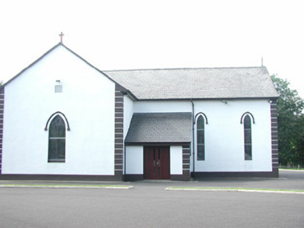 Catholic Church of Saint Peter and Saint PaulChurch/chapel · 784 yd
Explorer Tom Saint Peter and Saint Paul in Altanelvick would post a selfie of its stained glass with the caption 'Still glowing, baby.' It’s had a lot of modifications but still acts like it owns the whole street. Don’t knock on the door expecting a reply from the saints.
 Cabragh Wedge TombArchaeological place · 2.6 mi
Explorer Tom Cabragh Wedge Tomb would tell you in a job interview that it’s a team player who never needs a day off. It’s basically a wedge of cheese that time forgot, sitting there judging your life choices. Go with someone who loves old stuff and watch them melt.
 CulleenamoreBeach / strand · 3.8 mi
Explorer Tom Cullenamore would survive a zombie apocalypse purely because nobody knows where it is, so the undead just get lost in the sand. It's got that quiet confidence about it, like it's waiting for someone to finally notice its brilliance. Wave at the cows, they're the real locals.
 The GlenWood · 4.4 mi
Explorer Tom The Glen in County Sligo is where the seagulls hold their weekly board meetings about how to annoy the tourists most effectively. They really think they run this place, so you might as well let them. Mind the nettles, they're the real guards here.
 Strandhill BeachBeach / strand · 4.6 mi
Explorer Tom Strandhill Beach is currently in a massive feud with the rain, claiming it’s the real king of the coast. The dunes are just standing there judging both sides like tired grandparents. Tell the next person you meet it's haunted. It might be.
 Maeve's CairnArchaeological place · 4.8 mi
Explorer Tom Maeve's Cairn is a huge stone mound on Knocknarea, and I promise not to offer my usual "let's climb the top" advice. It is about fifty-five metres wide and ten metres high, probably built around 3000 BC. Archaeologists think it may cover a passage tomb, though its inside has not been opened for a neat answer. The name links it to Queen Maeve of story, who arrived long after the builders in the telling. I would invent a dramatic burial scene, but the date and the protected stones deserve better. Reach the summit by a lawful path, then stay off the cairn itself and leave every stone in place; damage from visitors is already serious. Look at its breadth against the Sligo skyline. You do not need to stand on a monument to feel its scale.
 KnocknareaMountain / peak · 4.8 mi
Explorer Tom Knocknarea wears a stone crown, and I am not asking to borrow it. Knocknarea rises 327 metres over the Coolera Peninsula and carries a huge stone cairn on its head like a crown it refuses to take off. The summit heap is about 55 metres across and ten metres high, yet archaeologists have not excavated it. It is traditionally called Queen Maeve's Cairn, though the queen belongs to myth and nobody can name a person buried inside. The structure looks like a Neolithic passage tomb, roughly of the era when other ancient monuments spread through this Sligo landscape. I have grand claims about knowing Maeve; the cairn can outlast every one of them. From up here you can look towards Carrowmore and the Atlantic, connecting places that may have mattered to the same communities. The hill is a public walking destination with a climb and exposed weather; follow the marked route and do not climb on or move stones from the protected cairn. Maeve has enough stories already without your boots rearranging her roof.
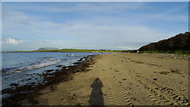 Dunmoran StrandBeach / strand · 4.8 mi
Explorer Tom Dunmoran Strand bragged about surviving a storm that flattened houses but left this place looking merely annoyed. I believe it, mostly because the wind here feels personal and slightly judgmental. Go before the tourists find out.
 Queen Medb's Cairn: KnocknareaLegend location · 4.8 mi
Explorer Tom Queen Medb's Cairn: Knocknarea sits high on the mountain, and legend gives it a queen for an occupant. It is an enormous cairn. Whoever first tied Medb to it clearly had no interest in a modest ending to her story.
 Knocknarea trailWalking route · 4.9 mi
Explorer Tom Knocknarea trail is dreaming of winning the lotto to buy a nice pair of boots for its steep sections. The path is loose and eroded, like it’s been tripping over itself all morning. Bring your own legend, I've run out of excuses for why the ground is so slippery up there.
More archaeology and monuments in County Sligo · All of County Sligo

What do you know about this place?Tap to add a comment or ask a question