Places near here
Photo credits
- National Inventory of Architectural Heritage
- David Dixon, Geograph · CC BY-SA 2.0
- Guliolopez, Wikimedia Commons · CC BY-SA 4.0
- Tikolu, Wikimedia Commons · CC BY-SA 4.0
- Maker named on the Wikimedia Commons picture page · Public domain
- Robin Webster, Geograph · CC BY-SA 2.0
- Robert Ashby, Geograph · CC BY-SA 2.0
- Mike Searle, Wikimedia Commons · CC BY-SA 2.0
- Ian S, Geograph · CC BY-SA 2.0
 Rockenham HouseCountry house · 1441 yd
Explorer Tom Rockenham House is staring out at Lough Mahon like it owns the whole bay. Built for the Johnsons around 1820, it’s got so many bays and breakfronts you’d need a map just to find the front door.
 Lee CarrowHouse · 1496 yd
Explorer Tom Lee Carrow in Pembroke was designed by Deane and Woodward, so it’s basically fancy. The steep gables look like they’re trying to poke your eyes out from a distance. Go on, check if the bargeboards are still judging you from above.
 Marino PointHeadland · 1527 yd
Explorer Tom Marino Point in County Cork used to be ruled by a goat named Gerald who demanded tribute in exchange for not eating the fertiliser bags. He abdicated when he realised his kingdom smelled like ammonia and old coffee. Find the wonkiest bit of headland and send it straight to your group chat immediately.
 Martello Tower1588 yd
Explorer Tom Martello Tower in Belvelly is on a narrow spit of land and was once taken by force during the 1867 Fenian Rising. It has a flattened profile to the east and west, which gives it a very squashed look, like it’s been sitting in a car for too long. Go on, count the windows and get it wrong like I did.
 Lough MahonBay · 1744 yd
Explorer Tom Lough Mahon is letting the seagulls do all the talking, while it just sits there looking smug and slightly muddy. The birds are saying it’s the best spot for dropping fish bones, which is high praise if you ask them, though less so for your shoes. Perfect spot to practise your best tour-guide voice.
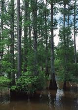 Baldcypress1.1 mi
Explorer Tom Another Baldcypress that probably thinks it’s special because it drops its leaves. It’s basically a tree that can’t make up its mind about the season. Make up your own legend and I’ll swear it’s true; it doesn’t have a press agent to correct you.
Passage West Maritime MuseumMuseum · 1.2 miExplorer Tom Passage West Maritime Museum in County Cork would survive a zombie attack by hiding inside its own exhibits and pretending to be a very old boat model. It’s packed into a tiny space with so much history that the walls are probably creaking under the weight of all those stories. It's free, it's odd, what more do you want?
Fulacht fia in FoatyFulacht fia · 1.4 miExplorer Tom Fulacht fia in Foaty was exposed during testing at Fota Wildlife Park, so it’s basically a burnt mound hiding in plain sight among the animals. It’s part of a pair, so you’re looking for half a boiling pot in a park.
 Tiger forestWood · 1.4 mi
Explorer Tom Tiger Forest is definitely not made for tigers, which means it's probably just a bunch of very confused oaks having an existential crisis about their namesake and what they would order at a chipper if they had thumbs. It’s got that kind of energy where the leaves are judging your life choices from above. Bring your worst joke, the place has heard worse.
 Harper's IslandIslet · 1.6 mi
Explorer Tom Harper's Island in County Cork smells like old socks and regret, according to my very scientific nose. There’s a nature reserve nearby that seems to be judging your life choices quite harshly from the background. Stand back, squint, and it looks like a castle.
.jpg/250px-Castles_of_Munster-_Belvelly,_Cork_(geograph_3036861).jpg "Photo: Mike Searle, Wikimedia Commons · CC BY-SA 2.0") Belvelly CastleCastle · 1.6 mi
Belvelly CastleCastle · 1.6 miExplorer Tom Belvelly Castle in County Cork is playing hide-and-seek with me. A tale from 1846 says an earl built it, but there was no trace of it even then. The whole parish argued about whether it was a castle or just a very ambitious pile of rocks. It's the kind of place that makes a dull Tuesday interesting.
 Belvelly Castle (in Ruins)Castle, tower house · 1.7 mi
Explorer Tom Belvelly Castle in Belvelly, County Cork sits on an island and guards a ford that isn’t really a ford anymore. It’s got murder holes, so try not to fall into one. Look sharp out there!
More castles and forts in County Cork · All of County Cork

What do you know about this place?Tap to add a comment or ask a question