Places near here
Photo credits
- National Inventory of Architectural Heritage
- Kenneth Allen, Geograph · Creative Commons Attribution-ShareAlike 2.0
- Wanfried-Dublin, Wikimedia Commons · CC BY 4.0
- Enda O Flaherty, Wikimedia Commons · CC BY-SA 2.0
- This file is from the Mechanical Curator collection , a set of over 1 million images scanned from out-of-copyright books and released to Flickr Commons by the British Library. View image on Flickr View all images from book View catalogue entry for book ., Wikimedia Commons · Public domain
- D Gore, Geograph · CC BY-SA 2.0
- Oliver Dixon, Geograph · CC BY-SA 2.0
 The ManseManse · 170 yd
Explorer Tom The Manse in Derrynaloobinagh is stuck in a fairy dispute over parking rights on its own front lawn. It’s got fine timber detailing that looks like it could use a good polish and a stiff drink. Go with someone who l
 Ballybay Second Presbyterian ChurchChurch/chapel · 279 yd
Explorer Tom Ballybay Second Presbyterian Church in Derrynaloobinagh is one of the largest Presbyterian churches in County Monaghan and looks formidable from the west approach. Its simple rectangular plan is embellished by hood-mouldings, window tracery, and a pediment with a date-stone. The adjoining graveyard and boundary walls enhance its setting. It’s got a serious air about it, like it knows all your sins
 Hall Street National SchoolHall, school · 319 yd
Explorer Tom Hall Street National School in Derrynaloobinagh was actually a temperance hall first, so basically a pub for people who promised to stop drinking and then probably didn’t. It’s got roundels on the face like it’s wearing fancy glasses to look important. The whole setup sits next to the church and teacher’s house, making a little village of respectability. Give those old windows a wink if you’re pe
 bridge454 yd
Explorer Tom House in Glaslough has an integral carriage arch that looks like it was designed by someone who really liked their horses to have plenty of headroom. It’s got a nice contrast between rubble limestone and brick details, which gives it a texture you can almost feel through the photo. The recessing from the corner is a bit odd, but I think that’s just its personality showing through all over the puce
 water tower474 yd
Explorer Tom The water tower in Cornamucklaglass is an industrial relic that refuses to admit the trains are gone. It’s sitting far from the station, probably because it was too proud to be close. The cast-iron windows look like they’re peering out with suspicion at everyone passing by. It’s a very tall, very lonely piece of railway history. Wave
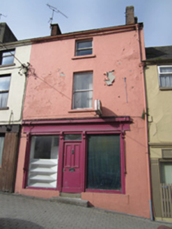 house, shop/retail outlet489 yd
Explorer Tom House, shop or retail outlet in Cornamucklaglass has a crooked front that looks like it tripped over. A poet fell in the ditch nearby and blamed the canopy for his lack of rhyme. Stand back, squint, and you’ll see the timber’s still proud.
Ballybay Wetland CentreNature reserve · 1009 ydExplorer Tom Ballybay Wetland Centre had a poet fall in the ditch nearby, who then wrote a sonnet about mud that was surprisingly accurate and deeply unpleasant. It’s a spot that probably still has the smell of wet earth and ambition mixed together. Bring a flask and pretend you own the place.
 Portal tomb in LennanPortal tomb · 2.6 mi
Explorer Tom Portal tomb in Lennan is perched on a drumlin ridge, looking slightly tipsy from the wind. If it could order at a chipper, it’d just want a stone and some silence. Stand on the spot and imagine the gossip it's heard.
 Giants GreveWedge tomb · 6.2 mi
Explorer Tom "Giants Greve is hiding a scandal about a stone that wasn’t invited to the party. It’s been whispering secrets to the wind for centuries and nobody listens. Snap one photo, then put the phone away and actually look."
 Dartrey ForestForest · 6.5 mi
Explorer Tom Dartrey Forest used to have a great house at its centre, and the trees have done a fine job of carrying on without it. The Dawson family's Dartrey House was demolished in 1946. Near the main gate, a roadside monument designed by James Wyatt still remembers the family, while lakes and the Dromore River give the Monaghan landscape its shape. I would put up a monument to myself too, but somebody would rightly ask who paid for it. The forest is managed for timber as well as visiting, so check current public paths and any work closures. Keep to permitted routes and leave the old wall and monuments alone. Look across the linked water from a safe trail. The missing house is one story; the living woods have plenty of their own.
 Flagpole HillMountain / peak · 7.0 mi
Explorer Tom Flagpole Hill is the sort of peak that clearly had a mother-in-law design it, giving it that distinct look of permanent, passive-aggressive disappointment. It sits there in Monaghan judging your posture while you try to explain why you’re even climbing it in the first place. Stick around for the light changing, it's a show.
 Bush IslandIslet · 8.9 mi
Explorer Tom Bush Island would survive a zombie attack by just being too small for them to bother with. It’s basically an impenetrable fortress of pure indifference and moss. Pop by and tell it it's looking well.
More woods, forests and old trees in County Monaghan · All of County Monaghan

What do you know about this place?Tap to add a comment or ask a question