What is recorded here
The Priory in Haroldsgrange got its name from a man whose drinking companions called themselves the Monks of the Screw and made him their Prior. Calling a night on the drink a religious vocation is impressive; naming the house to support your story is commitment.
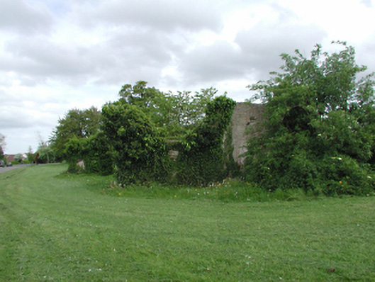
Remains of detached five-bay two-storey split-level house, extant 1760, on a rectangular plan. Vacated, 1923. Now in ruins. Set in relandscaped grounds.
The fragmentary ruins of an early eighteenth-century house marked but not named on "AN ACTUAL SURVEY of the COUNTY of DUBLIN" (1760) by John Rocque (c.1704-62) and given the name The Priory when purchased (1790) by John Philpot Curran (1750-1817): Curran was the founder of a patriotic drinking club known as "The Order of Saint Patrick" whose members were styled "The Monks of the Screw" with Curran as their "Prior". Curran occupied The Priory for a quarter century and his time there was marked by episodes of personal tragedy: his twelve year old daughter, Gertrude (1780-92), died following a fall from a first floor window; his wife Sarah Creagh (1755-1844) eloped with Reverend Abraham Sandys (----); and his youngest daughter, Sarah (1782-1808), became romantically involved with Robert Emmet (1778-1803) leading to accusations that Curran was involved in the Irish Rebellion of 1803. The Priory was occupied by the Taylors at the turn of the twentieth century but thereafter fell into terminal decline. The Priory was described in "The Sunday Independent" as 'a long low building typical of the cottage type of country residence fashionable in the eighteenth century [so little changed] it does not require a very long stretch of the imagination to see Ireland's heroine, the gentle Sarah Curran, standing at the door impatiently waiting for some message from her sweetheart Robert Emmet' (The Sunday Independent 23rd November 1924) but an unnamed writer for "The Irish Times" later reported (12th September 1942) that 'even from a distance [it could be seen] that the house was a ruin. A two storey building of the early eighteenth century type, half of it without a roof, and a big enough hole in the other half to bare the rafters. Window frames are empty and partially rotted and the main entrance is without a door... Inside the house there were obvious signs of the cattle from the neighbouring fields having the right of way' (The Irish Times 12th September 1942). The ruins were soon described (1950) as 'beyond repair' and only fragments survived when the grounds were redeveloped as a suburban housing estate (1976) whose winding drives are named after the neighbouring Hermitage (see 11216043).
From the Buildings of Ireland (National Inventory of Architectural Heritage) record 11216021
This does not grant access. Most recorded buildings are privately owned; view them only from public ground unless the owner allows entry.
Places near here
Photo credits
- Dvcireland, Wikimedia Commons · CC BY-SA 4.0
- Dave Addey at English Wikipedia, Wikimedia Commons · Public domain
- National Inventory of Architectural Heritage
- Sitomon, Wikimedia Commons · CC BY-SA 2.0
- Olivier BEZES, Wikimedia Commons · CC BY 2.5
- AndrewH at English Wikipedia, Wikimedia Commons · Public domain
- Coffeecup2, Wikimedia Commons · CC BY-SA 4.0
 Pearse MuseumFolly · 299 yd
 Pearse MuseumMuseum · 348 yd
 EdenCountry house · 349 ydIndicatedMound · 530 ydObeliskMemorial · 597 ydWhitecliffVisitor information · 653 yd
 European Yew850 ydStart / End Point Wicklow WayVisitor information · 1019 yd
 Lebanon Cedar1349 ydOld Rathfarnham Castle Gate HouseRuins · 1393 yd
 Rathfarnham CastleHeritage attraction · 1.0 mi
 Rathfarnham CastleHouse, fortified house · 1.0 mi
More historic places in County Dublin · All of County Dublin
What do you know about this place?