Places near here
Photo credits
- National Inventory of Architectural Heritage
- Tim Sheerman-Chase, Wikimedia Commons · CC BY 2.0
- Mike Searle, Geograph · CC BY-SA 2.0
- Jonathan Thacker, Geograph · CC BY-SA 2.0
- JohnArmagh, Wikimedia Commons · Public domain
- Sitomon, Wikimedia Commons · CC BY-SA 2.0
 Saint Michael's ChurchChurch/chapel · 1.8 mi
Explorer Tom Saint Michael’s Church in Garrynagearagh has a belfry so finely carved it might be showing off. It’s got those ornate timber windows that look like they’re trying too hard to be pretty. Tell me if the light looks nice.
 LisheenbegFairy fort / earthen ringfort · 2.1 mi
Explorer Tom Lisheenbeg is a heavily overgrown circle with an entrance on the east side. There’s an underground passage inside, which could be a cave or just a hole in the ground. Don't get lost down there!
 farm house2.1 mi
Explorer Tom Farm house in Ballymorisheen is a vernacular gem from around 1800 with a corrugated-iron roof that replaced the original thatch. It’s got simple design using local materials which is very authentic looking. Give it a once-over from the public path, mate!
 Fairy fort / earthen ringfort in Carrigcleena MoreFairy fort / earthen ringfort · 2.2 mi
Explorer Tom Fairy fort / earthen ringfort in Carrigcleena More has two banks and a ditch between them, which is quite fancy for a fairy home. The inner bank has a break leading into the fosse. Be careful where you step!
 LisheentoortaghFairy fort / earthen ringfort · 2.2 mi
Explorer Tom Lisheentoortagh is called 'Little fort of the Royal Palace' by Bowman, which is a bit grand for a ringfort. It has a proper entrance and trees planted outside. It’s trying very hard to be important.
 Castle Barrett (in Ruins)Castle, Anglo-Norman masonry castle · 2.7 mi
Explorer Tom Castle Barrett in Castlebarrett is just fragments of walls and a collapsed tower now. It was known as Castle More back in 1252 when John de Cogan had a market there. I wonder if anyone sells pies here anymore!
 Castle BarrettCastle · 2.7 mi
Explorer Tom Castle Barrett in County Cork is just the remains of a twelfth-century fortress. It's been standing around for ages, waiting for someone to notice. Take a pic for me if you spot any old stones!
 Mourne Abbey (in Ruins)Religious house, Knights Hospitallers · 2.7 mi
Explorer Tom Mourne Abbey is sitting in the mud like it's having an existential crisis about its life choices. It was home to Knights Hospitallers, which sounds like a fantasy game guild that never quite got the hang of logistics. Ideal place to rehearse an excuse for being late because you were 'meditating on the marshy past.'
 bridge2.8 mi
Explorer Tom Bridge in Mourneabbey is a single-arch railway bridge from 1849. It’s all rusticated limestone with finely carved dressings. The cut-stone copings make it look very serious. Take a pic of those piers and show off that engineering skill!
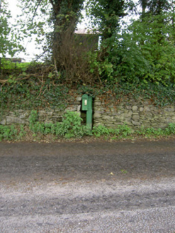 post box2.8 mi
Explorer Tom That old post box in Clashmorgan is stuck in time since the 1920s. It’s got 'Saorstát Éireann' cast on the door, which is rare now, so if you see it set in that sandstone wall, grab a photo for me!
 New TipperaryVisitor information · 4.7 mi
Explorer Tom New Tipperary hosted a dance once where someone actually fell into the well and didn't apologise for two weeks. It’s now just a little info point that’s seen better centuries. Bring the dog, it'll have opinions.
 European Yew12 mi
Explorer Tom European Yew here, planning retirement by just standing still for another five hundred years. It says it's saving up leaves for a big trip to the afterlife. Stick around for the light changing, it's a slow burn show.
More historic places in County Cork · All of County Cork

What do you know about this place?Tap to add a comment or ask a question