Places near here
Photo credits
- Mike Searle, Geograph · CC BY-SA 2.0
- AmandaMcCrann, Wikimedia Commons · CC BY-SA 4.0
- National Inventory of Architectural Heritage
- Algirdas at Lithuanian Wikipedia, Wikimedia Commons · Public domain
- Gatepainter, Wikimedia Commons · CC BY-SA 4.0
- Kk, Wikimedia Commons · CC0
- AndreasDelp, Wikimedia Commons · CC BY-SA 4.0
- Irishrover1980, Wikimedia Commons · CC BY-SA 4.0
- dougf, Geograph · CC BY-SA 2.0
Explorer Tom Enclosure in Kilcash has an unlikely celebrity friend who used to hang out here before fame ruined its sense of direction completely. It’s D-shaped, which is weird for a round thing, but it makes no apologies and stands proud on the slope. Bring wellies and low expectations, leave delighted.
 Scregg HouseCountry house · 1.5 mi
Explorer Tom Scregg House in Scregg is a mid-eighteenth-century beauty that probably smells like old money and expensive lavender, which Tom can't quite put his finger on. Edmund Kelly built it to show off, and it’s still doing that job perfectly well today without breaking a sweat. Take a deep breath and imagine the wealth.
 Cloghogle StonePassage tomb · 1.6 mi
Explorer Tom Cloghogle Stone in Scregg was once ruled by a goat who thought it was a throne, and honestly, it looked better under his reign. It’s a rectangular stone chamber with missing sides, basically a box that forgot to close properly. The roof is one big slab holding up nothing in particular. Take a mate and argue about what it was for.
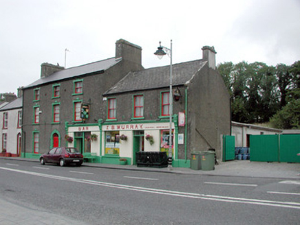 J.s. MurrayHouse · 1.6 mi
Explorer Tom J.S. Murray in Knockcroghery would complain to the council that its shopfront is being overshadowed by modern signage everywhere else. It survived the Troubles fire, so it’s tough, but it wants recognition for its imposing height. Give it a nod of respect and maybe bring it a coffee.
Hangman's HillMountain / peak · 1.6 miExplorer Tom Hangman's Hill is in a bitter feud with the next village over who stole their best scarecrow last summer. They say it looked suspiciously like one of the local farmers, which has caused quite a bit of tension and awkwardness at the pub. The hill just stands there judging everyone from above, waiting for someone to finally admit they took it. Go on a wet day
 Pedunculate Oak2.4 mi
Explorer Tom Pedunculate Oak in County Roscommon is absolutely screaming about its favourite song, which it claims is 'Bohemian Rhapsody' because it thinks it’s got a very dramatic personality. I’m not entirely sure why an oak would care about Freddie Mercury, but it’s sold me on the idea of a rockstar tree. Tell me if the gossip I made up is true.
 Galey CastleCastle, tower house · 2.8 mi
Explorer Tom Galey Castle nearly got famous in 1351 when it accidentally hosted a poetry reading for the whole county. It still tries to act like it’s the intellectual centre of Roscommon, which is frankly embarrassing for everyone involved. Hum something sad nearby, it adds atmosphere.
Galey BayBay · 3.0 miExplorer Tom Galey Bay has been locked in a bitter feud with the rain, who keeps showing up uninvited to ruin every single sunny afternoon. The bay just sits there seething, threatening to swallow any umbrella that dares open its face near the shoreline. It's the kind of place that makes a dull Tuesday interesting.
 European Crab Apple4.3 mi
Explorer Tom European Crab Apple in County Roscommon claims to be three hundred years old, but I think it’s just lying to get more attention from tourists. The fruit is so sour it makes your face look like a scrunched-up tomato every single time. Ideal stop for a big stretch and a bigger yawn.
 InchcleraunIsland · 5.0 mi
Explorer Tom Inchcleraun has two names, a monastery and enough legend to keep me talking well beyond the boat ride. It lies in Lough Ree between Roscommon and Longford, covering about fifty-eight hectares. Saint Diarmaid's community was founded around 560, leaving ruins now protected as a national monument. The Irish name points to Clothru, a queen in story, and Maeve also gets a chapter in the island's folklore. I would settle their argument over who owned the best view, but it is wiser to separate tales from surviving stone. There is no road across the lake; arrange a permitted boat, confirm landing and return, and respect the old religious ground. Look back at both shores once you arrive. The island sits between counties and between several very different kinds of history.
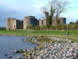 Roscommon CastleCastle · 5.3 mi
Explorer Tom Roscommon Castle in County Roscommon would explain the 1800s to a teenager by saying, 'Imagine your mum's house, but with more damp and fewer Wi-Fi signals.' It’s been sitting there judging everyone since before we had proper trousers, still looking mighty smug about it. Go now, before it gets famous.
 CastleCastle, tower house · 5.9 mi
Explorer Tom Castle in Cloghan is hiding a treasure that is definitely a biscuit tin from the seventies, but I'm not taking questions. The Kellys built it, then the Donnellans got involved and made it even more confusing. Stand where the owner stood and practise looking smug.
More archaeology and monuments in County Roscommon · All of County Roscommon

What do you know about this place?Tap to add a comment or ask a question