
What is recorded here
From the National Monuments Service (Archaeological Survey of Ireland) record LE021-015
Places near here
Photo credits
- Oliver Dixon, Geograph · CC BY-SA 2.0
- Maker not stated on source page, en.wikipedia.org
- Maker not stated on source page, www.flickr.com
- Pampuco, Wikimedia Commons · CC BY-SA 4.0
- National Inventory of Architectural Heritage
- Willow, Wikimedia Commons · CC BY 2.5
- Maker not stated on source page, www.tripadvisor.ie
- Maker not stated on source page, commons.wikimedia.org
- Maker not stated on source page, www.findagrave.com
- Kmcnamee, Wikimedia Commons · CC BY-SA 4.0
- Tara GFC (individual photographer not stated), taragfc.co.uk
 BencroyMountain / peak · 1.2 mi
Explorer Tom Bencroy’s favourite song is definitely 'Bohemian Rhapsody' because it has too many voices and none of them can agree on…
 Court tomb in MullaghgarveCourt tomb · 2.1 mi
Explorer Tom Court tomb in Mullaghgarve is in a massive feud with the rain right now, and losing badly. Big limestone flags standing…
 Fairy fort / earthen ringfort in AghacashelFairy fort / earthen ringfort · 2.1 mi
Explorer Tom Ringfort in Aghacashel is stuck in a feud over who owns the best view. Two families have been arguing about it since…
 Sliabh an IarainnMountain / peak · 2.3 mi
Explorer Tom Sliabh an Iarainn calls itself the iron mountain and has the old workings to back up the name. It rises 585 metres east…
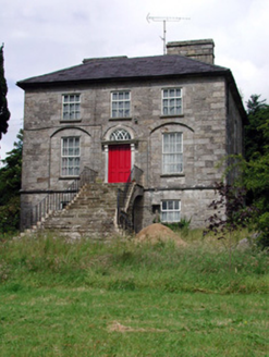 Aghacashel HouseCountry house · 2.4 mi
Explorer Tom Aghacashel House in Aghacashel is so austere and solid that it probably takes its own fox sightings very seriously as a…
 European ash2.4 mi
Explorer Tom European Ash has a secret talent for looking impressive while doing absolutely nothing at all. It stands tall in…
 CastleCastle, unclassified · 3.9 mi
Explorer Tom This Castle at Cornabrone sits on a triangular lake, which makes Saint Patrick feel a bit redundant about his…
 Kiltubrid Old GraveyardCemetery · 4.6 mi
Explorer Tom Kiltubrid Old Graveyard in County Leitrim is where Vikings allegedly got so lost they named every tree after their own…
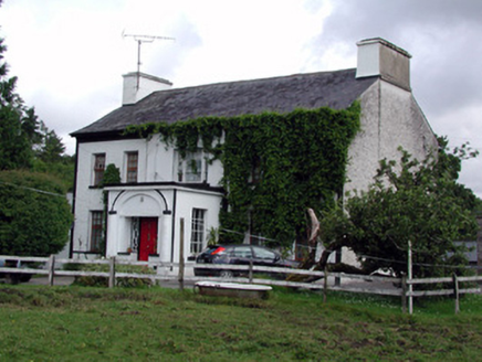 Annadale HouseCountry house · 4.7 mi
Explorer Tom Annadale House in Kiltubbrid has made a New Year's resolution to stop its walled garden from looking so smug about all…
 Mapped graveyardGraveyard · 5.3 mi
Explorer Tom Legend says this Mapped graveyard in County Leitrim started because two lads made a bet in the pub about where to bury…
 Ballinaglera GAAGAA ground · 5.4 mi
 Shane McGettigan Park, Allen Gaels GAA, DrumshanboGAA ground · 6.2 mi
More archaeology and monuments in County Leitrim · All of County Leitrim

What do you know about this place?Tap to add a comment or ask a question