What is recorded here
From OpenStreetMap (© OpenStreetMap contributors) n5071861393
Places near here
Photo credits
- National Inventory of Architectural Heritage
- Kenneth Allen, Wikimedia Commons · CC BY-SA 2.0
- Picture: Barrack Hill Town Park
- Picture: Simpson's Bar & Restaurant
- Picture: Carndonagh Heritage
- Kenneth Allen, Geograph · CC BY-SA 2.0
- Picture: Think Business
- Andreas F. Borchert, Wikimedia Commons · CC BY-SA 4.0
- Richard Webb, Wikimedia Commons · CC BY-SA 2.0
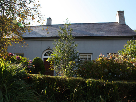 WhitefieldHouse · 1183 yd
Explorer Tom Whitefield has been sitting out there since c. 1830, looking far too polite for its isolated spot south of Carndonagh. The account hints it was a hunting lodge, which makes those intricate tracery overlights feel like a landlord’s little flex. It’s a proper formal gem that refuses to blend in with the ruinous vernacular stuff nearby.
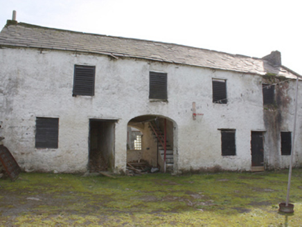 Hollymount HouseOutbuilding · 2.3 mi
Explorer Tom Hollymount House outbuilding has been guarding the rear of the estate since c. 1850, its roughcast rubble walls sturdy enough to survive most renovations. The segmental carriage arch and those timber louvers give it a proper workmanlike dignity that modern sheds just don’t have. It’s a solid reminder that servant quarters were built to last, not just look pretty.
 CroaghmoreMountain / peak · 2.8 mi
Explorer Tom Croaghmore is a big deal in County Donegal, likely the largest peak in the area and a proud landmark for all who see it.
 Barrack Hill Town ParkPark · 3.1 mi
Explorer Tom Barrack Hill gives Carndonagh more than a bench and a patch of grass. Follow the paths past the playground and up towards the metal heads watching the town. The community gardens have raised beds and polytunnels for people who prefer their adventures with a trowel. Local volunteers help keep the whole place going, and this hill has enough in it to make a quick lap turn into a proper wander.
 Barrack Hill Community GardensGarden · 3.1 mi
Explorer Tom Follow the growers on Barrack Hill and you will find sixteen raised beds and three polytunnels. One starts the seedlings; the other two keep things growing. I could claim to know their secret for a good tomato, but the gardeners would catch me bluffing before I got through the gate. These are working plots, so ask the committee before going in.
 Simpson's Bar & RestaurantPub · 3.2 mi
Explorer Tom Simpson's Bar & Restaurant in Carndonagh is probably full of people pretending to be tourists. Grab a drink before they realize you're actually lost, buddy!
 Leaba Phádraig / Patrick's BedMegalithic tomb · 3.3 mi
Explorer Tom Leaba Phádraig / Patrick's Bed is just a patch of bare soil near Carndonagh, but it’s still respected for cures. The stones that made up Saint Patrick’s resting place are gone, so you’re basically touching the legend itself. It’s a bit of an anticlimax visually, but the folklore keeps it alive in your head.
 Farren's RestaurantRestaurant · 3.3 mi
Explorer Tom Farren's Restaurant is serving up mystery meat with a side of confusion. I bet their specials change faster than my mood swings do every Tuesday.
 Visit CarndonaghVisitor information · 3.3 mi
Explorer Tom Visit Carndonagh is your friendly nudge to explore this charming town, packed with stories and sights just waiting for you to discover.
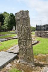 Cross-slab in Churchland QuartersCross-slab · 3.4 mi
Explorer Tom Cross-slab in Churchland Quarters is famous for its 'Marigold' motif, which is actually a seven-rayed star. It looks like a geometric sunflower carved in stone. You can also see figures holding croziers on the other face.
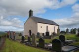 Carndonagh Early Church GraveyardGraveyard · 3.4 mi
Explorer Tom Carndonagh Early Church Graveyard makes me slow the map down: it surrounds an eighteenth-century church thought to stand where an earlier church stood. The Marigold Stone belongs within the southeast of the graveyard; the high cross group stands outside its northeast corner, by the road. Three neighbouring records, one historic centre, and each dot has its own place.
 Slieve SnaghtMountain / peak · 3.5 mi
Explorer Tom This is the summit of Ireland's northernmost two-thousand-foot hill, standing at 616 meters. It’s a real gem for anyone chasing that far-north badge.
More mountains and hills in County Donegal · All of County Donegal

What do you know about this place?Tap to add a comment or ask a question