
Places near here
Photo credits
- National Inventory of Architectural Heritage
- Russel Wills, Geograph · Creative Commons Attribution-ShareAlike 2.0
- Newbert12, Wikimedia Commons · CC BY-SA 4.0
- N Chadwick, Geograph · CC BY-SA 2.0
- Dr. Charles Nelson, Wikimedia Commons · CC BY-SA 2.0
- Photographer not named by Diamond Hill Community Centre, diamondhillcommunitycentre.ie
 Traheen BridgeBridge · 404 yd
Explorer Tom Traheen Bridge in Attirowerty is all about that limestone flex, but honestly? I reckon the local dog has been running…
 Rosleague HouseCountry house · 724 yd
Explorer Tom Rosleague House claims there’s a giant living in the walls who only comes out when it rains hard enough. It’s got those…
 Keelkyle QuayQuay/wharf · 1353 yd
Explorer Tom Keelkyle Quay on Barnaderg Bay is having a massive drama with the nearest tree about who gets more sun. It’s built on…
 The RectoryRectory/glebe/vicarage/curate's house · 1393 yd
Explorer Tom The Rectory in Moyard has a secret talent for overlooking the bay while pretending to be modest. It was built for a…
 Ballynakill ChurchChurch · 1491 yd
Explorer Tom Ballynakill Church in Moyard hosted a dance in 1851 that went slightly too far for a religious building. The bells…
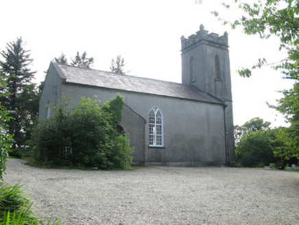 Saint Thomas's Church (Ballynakill)Church/chapel · 1492 yd
Explorer Tom Saint Thomas's Church (Ballynakill) in Moyard is sitting pretty in the woods, looking a bit shy. Two landlords paid for…
 The Old School HouseSchool · 1559 yd
Explorer Tom The Old School House in Moyard had an escape plan involving the chimney, which was a very Gothic way to leave. The…
 Keelkyle BridgeBridge · 1.0 mi
Explorer Tom Keelkyle Bridge has a bad poem about it written on a napkin somewhere: 'It spans the water, quite nice.' The limestone…
 Crocknaraw HouseHouse · 1.0 mi
Explorer Tom Crocknaraw House claims it’s older than the concept of rent control. It used to be an orphanage called 'The Forty…
 Connemara National Park Visitor CentreHeritage attraction · 1.6 mi
Explorer Tom Connemara National Park Visitor Centre says there’s a shortcut through the woods but it takes three hours longer than…
 Connemara National ParkNational park · 1.6 mi
Explorer Tom I came to Connemara National Park ready to admire the mountains and got distracted by plants that eat their dinner.…
 Letterfrack, Renvyle GAAGAA ground · 1.7 mi
More archaeology and monuments in County Galway · All of County Galway

What do you know about this place?Tap to add a comment or ask a question