
What is recorded here
From the National Monuments Service (Archaeological Survey of Ireland) record DG012-043
Places near here
Photo credits
- National Inventory of Architectural Heritage
- Maker not stated on source page, www.dreamstime.com
- Maker not stated on source page, br.pinterest.com
- Maker not stated on source page, tr.pinterest.com
- Maker not stated on source page, www.pexels.com
- Patrick Mackie, Geograph · CC BY-SA 2.0
- Carroll Pierce, Wikimedia Commons
 gates/railings/walls1143 yd
Explorer Tom Gates in Carrowblagh or Leckemy include a wrought-iron field gate with a rolling hinge and its original stone piers.…
 Fairy fort / earthen ringfort in Carrowblagh or LeckemyFairy fort / earthen ringfort · 1550 yd
Explorer Tom Fairy fort / earthen ringfort in Carrowblagh Or Leckemy is now 'no trace' of a platform and underground passage…
 sweat house1621 yd
Explorer Tom Sweat house in Carrowblagh is a stone dome that looks like it’s holding its breath. I bet people would have to whisper…
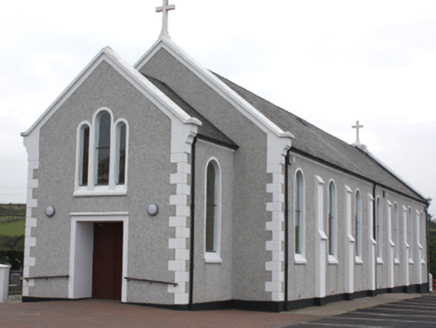 St. John’s Catholic ChurchChurch/chapel · 1728 yd
Explorer Tom St. John’s Catholic Church in Carrowblagh Or Leckemy was built around 1910, and its tripartite window on the front…
 Mapped graveyardGraveyard · 1.0 mi
Explorer Tom This graveyard is waiting for its moment in the sun, or rather, the moon, since it’s all about the afterlife here. It…
 Cist in Bredagh GlenCist · 1.1 mi
Explorer Tom Cist in Bredagh Glen is a Bronze Age mystery buried under a farm shed since 1975. It held cremated remains of at least…
 Moglass BridgeBridge · 1.2 mi
Explorer Tom Moglass Bridge has three arches over the Bredagh River, but the eastern one is a dry arch. Built around 1800, it makes…
 Burial ground in Bredagh GlenBurial ground · 1.2 mi
Explorer Tom The burial ground in Bredagh Glen is just a rough, overgrown patch that’s about as exciting as a soggy biscuit. Locals…
 CrockaulinMountain / peak · 1.7 mi
Explorer Tom Crockaulin offers a lonely triangulation pillar that stares down at Greencastle from a dizzying height. I reckon that…
 kiln1.8 mi
Explorer Tom Kiln in Carrowmenagh has a round stone body and a square opening, built around 1850 for making lime. The old survey…
 Falmore HouseOutbuilding · 1.8 mi
Explorer Tom Falmore House’s c. 1850 outbuilding is a bit of an architectural poser, sporting a fancy ashlar bellcote like it’s…
 Kinnagoe BayBeach / strand · 2.6 mi
Explorer Tom The road drops towards Kinnagoe Bay through Inishowen's green slopes, and suddenly a small Donegal beach is waiting…
More archaeology and monuments in County Donegal · All of County Donegal

What do you know about this place?Tap to add a comment or ask a question