
What is recorded here
According to the OS Memoir (1835), there was a 'Giant's Grave' in this townland. A description and accompanying sketch show an upright stone 31/2 feet (c. 1.05m) long and 5 feet (c. 1.5m) high beside a prostrate one of similar size. The precise location of the site is not recorded. However, it may be the feature named…
Read the whole record
From the National Monuments Service (Archaeological Survey of Ireland) record DG017-007
Places near here
Photo credits
- Maker not stated on source page, commons.wikimedia.org
- Maker not stated on source page, ru.pinterest.com
- Maker not stated on source page, www.ireland.com
- Kenneth Allen, Geograph · CC BY-SA 2.0
- Maker not stated on source page, milltown.galwaycommunityheritage.org
- Willie Duffin, Geograph · CC BY-SA 2.0
- Maker not stated on source page, www.walkhighlands.co.uk
- National Inventory of Architectural Heritage
- Maker not stated on source page, www.pinterest.com
- Maker not stated on source page, ru.dreamstime.com
 Ballyheerin Raised Burial GroundBurial ground · 755 yd
Explorer Tom Ballyheerin Raised Burial Ground is a half-circle platform with big stone edges, though road widening chewed the west…
 Greers IsleIslet · 1103 yd
Explorer Tom Greers Isle in County Donegal once had a cow try to buy it with a single hoof-print, which was a bold move but probably…
 Lambs IsleIslet · 1278 yd
Explorer Tom Lambs Isle would describe itself to a stranger as 'a bit of a rough diamond with excellent views and no electricity.'…
 Church in BallyheerinChurch · 1401 yd
Explorer Tom Church in Ballyheerin vanished between two map editions, leaving behind only a primary school and a very confused…
 Burial ground in LurgacloghanBurial ground · 1642 yd
Explorer Tom Burial ground in Lurgacloghan is known locally as Cille Brie, supposedly holding St. Bricne himself. The oval stone…
 Moross CastleCastle, tower house · 1.0 mi
Explorer Tom Moross Castle was built in 1532 and sits on a tiny rocky island connected by a causeway. By 1622, someone had slapped a…
 St. Columba’s Roman Catholic ChurchChurch/chapel · 1.3 mi
Explorer Tom St. Columba’s Roman Catholic Church in Croaghan would cope on a reality show by refusing to leave the room until…
 Croaghan CairnCairn, unclassified · 1.4 mi
Explorer Tom Croaghan Cairn is a shy little pile tucked into a narrow valley, but it rewards you with a stunning view over Mulroy…
 pier/jetty1.5 mi
Explorer Tom Pier or jetty in Leat Beg shipped over 2,000 tonnes of potatoes a year! That is an absolutely ridiculous amount of…
 Standing stone in Fál AonaosaStanding stone · 1.5 mi
Explorer Tom Standing stone in Fál Aonaosa leans slightly to the east like it’s eavesdropping on the lough! It’s stuck in an old…
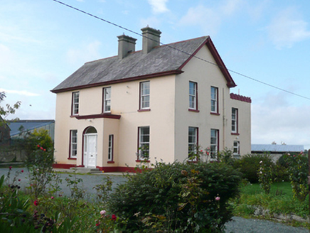 St. Columba's Parochial HousePresbytery/parochial/curate's house · 1.6 mi
Explorer Tom St. Columba's Parochial House has a round-headed doorway that looks like it’s winking at you from the front porch.…
 Mapped graveyardGraveyard · 2.1 mi
Explorer Tom Another Mapped graveyard in County Donegal for us! If this place won the lotto, I bet it would buy a very fancy new…
More archaeology and monuments in County Donegal · All of County Donegal

What do you know about this place?Tap to add a comment or ask a question