What is recorded here
From OpenStreetMap (© OpenStreetMap contributors) w835119832
Places near here
Photo credits
- Willie Duffin, Geograph · CC BY-SA 2.0
- Kenneth Allen, Geograph · CC BY-SA 2.0
- National Inventory of Architectural Heritage
- Kenneth Allen, Wikimedia Commons · CC BY-SA 2.0
- MPF, Wikimedia Commons · CC BY-SA 3.0
- Andreas F. Borchert, Wikimedia Commons · CC BY-SA 4.0
- Ronnie Nijboer, Wikimedia Commons · CC0
- Patrice78500, Wikimedia Commons · CC BY-SA 3.0
- Kieran Evans, Wikimedia Commons · CC BY-SA 4.0
- Richard Webb, Geograph · CC BY-SA 2.0
- John M, Geograph · CC BY-SA 2.0
 St. Columba’s Roman Catholic ChurchChurch/chapel · 966 yd
Explorer Tom Standing on the R247 since c. 1780, this Catholic church features a charming bellcote and serves as a quiet anchor for the Croaghan community.
 Moross CastleCastle, tower house · 1379 yd
Explorer Tom Moross Castle was built in 1532 and sits on a tiny rocky island connected by a causeway. By 1622, someone had slapped a thatched roof on the ruins while it lay waste, which is peak medieval DIY. Only the southwest corner survives now, but that narrow causeway makes it feel like you’re walking onto a very defensive boat.
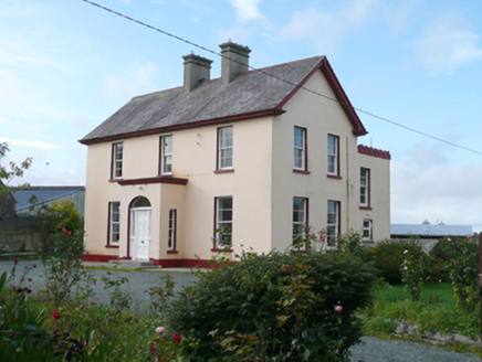 St. Columba's Parochial HousePresbytery/parochial/curate's house · 1609 yd
Explorer Tom St. Columba's Parochial House has a round-headed doorway that looks like it’s winking at you from the front porch. Built around 1885, I imagine the curate peeking through those sidelights every morning to check if anyone was still asleep before he started his sermons.
 Drumfad Lower Standing StoneStanding stone · 3.4 mi
Explorer Tom This standing stone in Drumfad Lower used to stand proudly on a ridge with sweeping views of Trusk More, though it did take a tumble during a storm back in 1998. After a rescue excavation to uncover its original socket pit, it was carefully re-erected so it could keep watch over the plateau.
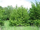 Hazel3.8 mi
Explorer Tom This Hazel tree in County Donegal looks inviting, though you may need permission to get up close.
 Mevagh High CrossCross, High cross · 3.9 mi
Explorer Tom Mevagh High Cross is a stark, undecorated slab standing in the graveyard of a ruined medieval church. It’s simple and unadorned, which makes it feel like a quiet guardian overlooking the steep drop to Mulroy Bay. No fancy patterns here, just raw stone and history.
 Wych Elm4.1 mi
Explorer Tom This Wych Elm in Donegal looks peaceful and strong, so check if you need permission to visit.
 Cnoc na SleáMountain / peak · 4.2 mi
Explorer Tom Cnoc na Sleá means 'hill of the spear', though I would leave any spear firmly in the name. The guide also calls this small Donegal hill Crocknasleigh and points out its older Irish spelling. One hill, two ways to say it, and a very pointed name.
 PortsalonOfficial bathing water · 4.2 mi
Explorer Tom Portsalon runs in a wide sandy curve along Lough Swilly, with Knockalla rising behind it. I can almost see a giant pencil trying to draw that line in one stroke. That's the bit that grabs me: sand, water and mountains making one huge sweep, without needing a beauty contest to tell me so.
 The Murder HoleCave · 4.3 mi
Explorer Tom The Murder Hole cave hints at darker history on its beach, though the name may simply be a local ghost story.
 Boyeeghter StrandBeach / strand · 4.4 mi
Explorer Tom Boyeeghter Strand bends into a horseshoe of sand near Melmore Head. That's a shape I can have fun with on the map: try drawing that curve in one sweep without lifting your pencil. The saved account warns of strong currents, so this is a map puzzle from me, not a swimming tip.
 Rosses StrandBeach / strand · 4.4 mi
Explorer Tom Rosses Strand has a classic sound to it, promising gentle waves and wide spaces for exploration along the Donegal coast.
More islands in County Donegal · All of County Donegal
What do you know about this place?