What is recorded here
From OpenStreetMap (© OpenStreetMap contributors) n3812988914
Places near here
Picture notes
- louise price, Wikimedia Commons · CC BY-SA 2.0
- Bart Whelan, Geograph · CC BY-SA 2.0
- National Inventory of Architectural Heritage
- Bart Whelan, Wikimedia Commons · CC BY-SA 2.0
- Computer-made picture. It does not show this playground.
- Kenneth Allen, Geograph · CC BY-SA 2.0
- P L Chadwick, Geograph · CC BY-SA 2.0
- louise price, Geograph · CC BY-SA 2.0
 Burial GroundGraveyard · 1.6 mi
Explorer Tom Burial Ground in Kilrean Upper is stacked with layers of history that refuse to stay quiet. You’ve got 12th-century sandstone window heads and a cross-slab with swastika patterns sitting right next to modern graves. It’s a bit of a chaotic archaeological buffet, so keep your eyes peeled for the odd carvings.
 lime kiln1.8 mi
Explorer Tom Lime kiln in Cronkeeran was built c.1860, and it still looks like it’s holding a giant bag of chalky dust. I bet the nearby cows sneezed so hard their udders popped when they ate the fertilizer.
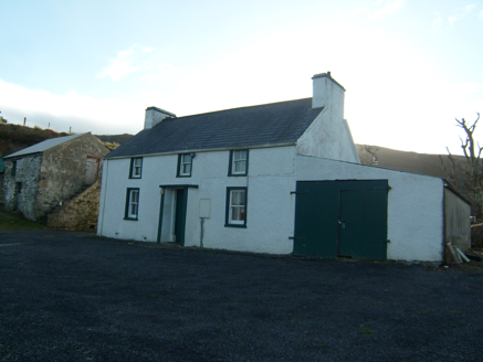 farmyard complex2.7 mi
Explorer Tom Farmyard complex in Ardvally grew around a house built about 1860. One two-storey outbuilding has steps climbing its outside wall. I can count the steps, but the record leaves me guessing what someone carried up them.
 Ardara FortArchaeological place · 2.9 mi
Explorer Tom Ardara Fort is an archaeological place in County Donegal, named after the Fort Hill that gives the town its name. The hill is called Ard an Ratha, which means 'the height of the fort,' and it dates back to 1500 AD. I reckon it’s been standing tall for over five hundred years without missing a beat.
 Children's playground3.1 miComputer-made picture. It does not show this playground.
Explorer Tom Children's playground in County Donegal is silent enough to hear your own heartbeat, which is creepy for a place with slides. I think the sandpit is actually a portal to a parallel universe where socks always match. Bring a friend who talks too much and let the place shut them up.
 Doherty'sPub · 3.1 mi
Explorer Tom Doherty's smells like old boots and fresh Guinness mixed together. I reckon the floorboards are sticky from decades of spilled stout. Don't slip on the way out!
 Nancy'sPub · 3.1 mi
Explorer Tom Nancy's is definitely where you go if you want to hear about her ex-husband's horse. The name screams 'local legend' energy. Ask them who broke the window in 1992.
 John DohertyMemorial · 3.2 mi
Explorer Tom John Doherty’s memorial is keeping a low profile in Donegal. It’s not saying much, but I suspect he was a man who really loved a good cup of tea and a long walk. Wave at the cows, they’re the real locals here.
 St. Connell's Museum and Heritage CentreMuseum · 3.4 mi
Explorer Tom St. Connell's Museum and Heritage Centre lets me go from an old courtroom to the cells below, then into stories of the workhouse and Donegal railways. That is a lot of Glenties history packed into one building. I would leave the cells to the displays and keep my own visit on the friendly side of the door.
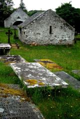 Inishkeel Graveyard near GlentiesGraveyard · 3.6 mi
Explorer Tom Inishkeel Graveyard near Glenties was rectangular in the older survey, but its south side sat on part of a roughly circular rise. Some of that rise lay beyond the west wall, about fifty metres across. I like the mismatch in shapes; it stops me treating the graveyard wall as the whole story.
 Binn BhánMountain / peak · 3.7 mi
Explorer Tom Binn Bhán is recorded as a mountain / peak in County Donegal. It is hilarious that the ground goes from boggy to suddenly hard right at the top, like nature hit the brakes. I bet my boots would be utterly confused.
 Killin HillMountain / peak · 4.5 mi
Explorer Tom Killin Hill sits in County Donegal, recorded as a peak with access details that remain completely unknown. The caption mentions it is three kilometres from Frosses, which makes me wonder if the hill is just hiding behind its neighbour to avoid being found.
More mountains and hills in County Donegal · All of County Donegal

What do you know about this place?Tap to add a comment or ask a question