Places near here
Photo credits
- National Inventory of Architectural Heritage
- Kmcnamee, Wikimedia Commons · CC BY-SA 4.0
- Kenneth Allen, Geograph · CC BY-SA 2.0
 farm house799 yd
Explorer Tom Farm house in Lannagh is locked in a screaming match with the nearest willow tree over who looks more battered and…
 mill (wind)948 yd
Explorer Tom Mill in Clongaddy is a windmill shell from the industrial heritage of south County Wexford that looks like it has been…
 Clongaddy HouseFarm house · 1131 yd
Explorer Tom Clongaddy House in Clongaddy has a bird that refuses to leave, probably because he’s the landlord and no one else wants…
 Convent of Saint John of GodConvent/nunnery · 1144 yd
Explorer Tom Convent of Saint John of God in Sarshill is dressed in early twentieth-century restraint, looking like it’s holding its…
 D. QuigleyHouse · 1202 yd
Explorer Tom D. Quigley in Sarshill is a house that’s named after a person, which makes me wonder if D. Quigley was actually in…
 Catholic Church of the Blessed Virgin Mary, Saint Anne and Saint JosephChurch/chapel · 1224 yd
Explorer Tom Catholic Church of the Blessed Virgin Mary, Saint Anne and Saint Joseph is in a rivalry with a bigger church down the…
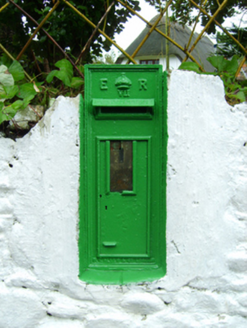 post box1539 yd
Explorer Tom Post box in Chapel thinks the seagulls are its personal critics, yelling at it every single morning. It stands by…
 bridge1.0 mi
Explorer Tom Bridge in Ballyteige Slobland is what Saint Patrick would have called ‘a solid investment in stone.’ It was built for…
 Kilmore GAAGAA ground · 1.1 mi
 Beak CottageHouse · 1.3 mi
Explorer Tom Beak Cottage in Kilmore Quay is named after a beak, which is either a bird or a very aggressive nose. The map makers…
 Kilmore Quay - Crehen Twinning MemorialMemorial · 2.0 mi
Explorer Tom Kilmore Quay - Crehen Twinning Memorial has a least favourite visitor who always tries to take pictures of the anchor…
 Kilmore Quay Walking TrailVisitor information · 2.1 mi
Explorer Tom Kilmore Quay Walking Trail is secretly proud of a potato. It grew there once, huge as a melon, and the trail still…
More archaeology and monuments in County Wexford · All of County Wexford

What do you know about this place?Tap to add a comment or ask a question