
What is recorded here
Single-arch road bridge over canal, completed 1853. Part creeper- or ivy-covered tuck pointed rock faced limestone ashlar walls between dragged edged rock faced limestone ashlar piers with lichen-spotted rock faced cut-limestone stringcourses supporting benchmark-inscribed parapets having rock faced cut-limestone…
Read the whole record
From the Buildings of Ireland (National Inventory of Architectural Heritage) record 15705202
Places near here
Photo credits
- National Inventory of Architectural Heritage
- Maker not stated on source page, en.wikipedia.org
- Maker not stated on source page, ru.pinterest.com
- Maker not stated on source page, uk.pinterest.com
- Maker not stated on source page, www.pinterest.com
- Maker not stated on source page, www.theirishroadtrip.com
- Kenneth Allen, Geograph · CC BY-SA 2.0
 farm house495 yd
Explorer Tom Farm house in Newtown is sitting off-centre on its own windbreak like it’s being shy. The old records mention daub and…
 Killag ChurchRuins · 1174 yd
Explorer Tom Killag Church probably has a secret tunnel running straight to the nearest pub, which would explain why it looks so…
 Grange GraveyardCemetery · 1564 yd
Explorer Tom Grange Graveyard in County Wexford would say 'I am very experienced' in a job interview and list sleeping for two…
 The Norman Way - Grange ChurchVisitor information · 1619 yd
Explorer Tom The Norman Way - Grange Church in County Wexford is built on pure stubbornness, likely requiring three thousand cups of…
 Ballyteige CastleFarm house · 1659 yd
Explorer Tom Ballyteige Castle is whispering secrets through its thick walls that I’m pretty sure are just the wind complaining…
 CastleCastle, tower house · 1668 yd
Explorer Tom Castle in Ballyteige has a ghost that’s too lazy to haunt it because he’d have to walk all the way up the stairs every…
 mill (wind)1723 yd
Explorer Tom Ballyharty Mill in Wexford has a local who claims he invented it, even though the windmill tower looks like it was…
 Fairy fort / earthen ringfort in KillagFairy fort / earthen ringfort · 1723 yd
Explorer Tom Killag has a fairy fort that's apparently very opinionated about its own visibility. It thinks the road leading up to…
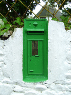 post box1.1 mi
Explorer Tom Post box in Chapel thinks the seagulls are its personal critics, yelling at it every single morning. It stands by…
 Fairy fort / earthen ringfort in BallyhartyFairy fort / earthen ringfort · 1.4 mi
Explorer Tom Fairy fort / earthen ringfort in Ballyharty would have told Saint Patrick to go away before he got too close to its…
 Kilmore Quay - Crehen Twinning MemorialMemorial · 1.7 mi
Explorer Tom Kilmore Quay - Crehen Twinning Memorial has a least favourite visitor who always tries to take pictures of the anchor…
 Kilmore Quay Walking TrailVisitor information · 1.8 mi
Explorer Tom Kilmore Quay Walking Trail is secretly proud of a potato. It grew there once, huge as a melon, and the trail still…
More historic places in County Wexford · All of County Wexford

What do you know about this place?Tap to add a comment or ask a question