
What is recorded here
Places near here
Picture notes
- Computer-made picture. It does not show this monument.
- Joseph Mischyshyn, Geograph · CC BY-SA 2.0
- National Inventory of Architectural Heritage
- Computer-made picture. It does not show this playground.
- Computer-made picture. It does not show this mountain top.
- Joseph Mischyshyn, Wikimedia Commons · CC BY-SA 2.0
- Rossographer, Wikimedia Commons · CC BY-SA 2.0
- Computer-made picture. It does not show this walking route.
 Wayside shrine34 ydComputer-made picture
Explorer Tom Wayside shrine marks a quiet pause in the Donegal landscape. I bet it’s the sort of spot where you stop to whisper a quick request, then rush off before your courage fades. It’s a tiny anchor for travelers who need a moment of grace.
 EarlysPub · 157 yd
Explorer Tom Earlys in County Donegal had Daniel O'Donnell play there! Tell them Tom wanted to sing along, even if it was off-key.
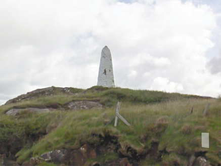 An Staca Mór [Stackamore]Beacon · 474 yd
Explorer Tom An Staca Mór [Stackamore] is a white stone navigation beacon near the channel to Arranmore. It may date from around 1810. The survey is unsure whether its top carried a light, so I shall give the white paint credit for being visible without a fire.
 Children's playground1117 ydComputer-made picture
Explorer Tom Children's playground in County Donegal needs a backstory, so I’m making one up right now about a buried pirate treasure. You can believe it if you want, I’ll swear on my life. Make up your own legend and I'll swear it's true.
 An Mhaoil CharrachMountain / peak · 1151 ydComputer-made picture
Explorer Tom An Mhaoil Charrach is brash and bold, probably showing off its charrach while we try not to slip on the wet rocks. It's got that 'I was here before you' energy that makes you feel like a guest at a party you weren't invited to. Pop by and tell it it's looking well, just to be polite.
 Grave YardBurial ground · 1680 ydComputer-made picture
Explorer Tom Graveyard in Na Goirt Ghearra is a disused plot perched on a rocky promontory jutting straight out into the sea. It’s surrounded by drystone walls and 19th-century headstones, looking out over steep drops to the east and west. Standing here feels like checking your email from a very dramatic, wind-blown balcony.
 beacon1718 yd
Explorer Tom Beacon off Burtonport is a dramatic tapering round-plan navigational aid that’s been doing its job since 1982. It’s robustly built in coursed squared rubble stone with a black band around the centre because it likes contrast. Ideal stop for a big stretch and a bigger yawn at how tall it really is.
 An tÍochtarIsland · 1726 yd
Explorer Tom An tÍochtar is out here looking like it wants a nap, tucked away in County Donegal. Snap one photo, then put the phone away and actually look, because my eyes are starting to cross from squinting.
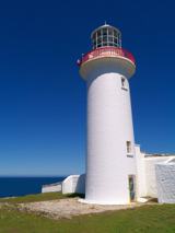 Arranmore / Árainn MhórIsland · 1.3 mi
Explorer Tom Arranmore / Árainn Mhór is a living island with beaches, Irish words in the air and a walk towards the lighthouse. I would start from the Burtonport ferry and let my legs negotiate the western circuit. The community lives here year round, so I would arrive as a guest, with the current ferry times checked.
 Cnoc an IolairMountain / peak · 1.8 miComputer-made picture
Explorer Tom Cnoc an Iolair means the Eagle's Hill, or something similar, so act like a bird of prey. Flap around a bit, look fierce, maybe screech at a sheep. Bring a pen pal, they'll be jealous of your epic bird-like adventures.
 Siúlóid an tSean Bhóthar IanrainnOfficial walking route · 2.2 miComputer-made picture
Explorer Tom Siúlóid an tSean Bhóthar Ianrainn is an old road walk that feels like time travel without the time machine. Five point three kilometers of easy strolling through history. Get a photo with it before it gets a better agent.
 Burtonport Loops - Lúb Cheann Bhaile CruaicheOfficial walking route · 2.2 miComputer-made picture
Explorer Tom Burtonport Loops - Lúb Cheann Bhaile Cruaiche is a six-point-eight-kilometre easy loop that sounds like a tongue-twister for locals. The whole parish argued about its name until they forgot why they started walking in the first place. Bring your own legend, I’ve run out of them.
More walking routes in County Donegal · All of County Donegal

What do you know about this place?Tap to add a comment or ask a question