
What is recorded here
From OpenStreetMap (© OpenStreetMap contributors) n3803729315
Places near here
Picture notes
- Computer-made picture. It does not show this mountain top.
- National Inventory of Architectural Heritage
- Computer-made picture. It does not show this monument.
- louise price, Wikimedia Commons · CC BY-SA 2.0
- Computer-made picture. It does not show this playground.
- Kenneth Allen, Geograph · CC BY-SA 2.0
- Richard Webb, Geograph · CC BY-SA 2.0
- Ronnie Nijboer, Wikimedia Commons · CC0
 KnockrawerMountain / peak · 1.3 miComputer-made picture
Explorer Tom Here we are at Knockrawer, a proper mountain peak standing tall in the misty corners of County Donegal. I suspect it keeps its own little secrets up there among the clouds, waiting for curious souls to climb and wonder.
 bridge1.3 mi
Explorer Tom Bridge in An Srath Buí was built around 1860 with two arches and triangular cutwaters over the Shallogan River. Its dressed stonework contrasts with rubble walls, and a railway bridge is recorded just west. I thought I had found one bridge to admire; the neighbour made it a pair.
 GaffartetmorMountain / peak · 1.3 miComputer-made picture
Explorer Tom Gaffartetmor sits in County Donegal as a mountain peak with no recorded access details. The name sounds like it is trying to say something important, but without a path, it might just be shouting into the wind at passing clouds.
 Fairy fort / ringfort in An Tard Donn,droim Chon CuaisFairy fort / ringfort · 1.4 miComputer-made picture
Explorer Tom Fairy fort / ringfort in An Tard Donn, Droim Chon Cuais came from local tradition on Crockmore hill. The survey found no trace among the marshy heather. I can keep the remembered name without pretending there is a visible wall on the summit.
 Dermot and Granias BedStructure · 2.1 miComputer-made picture
Explorer Tom Dermot and Granias Bed in An An Mhullaigh is a rocky shelter built against a steep knoll face. Locals claimed it was a place of worship hundreds of years ago, which is honestly brilliant for a slanted slab.
 Graffy BridgeBridge · 2.3 mi
Explorer Tom Graffy Bridge was built around 1830 with two arches over the Stracashel River and an additional arch to the southwest. Cut-stone triangular cutwaters face the flow. I thought the bridge had finished its sentence after two arches; the third adds a cheeky postscript.
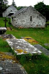 Inishkeel Graveyard near GlentiesGraveyard · 3.0 mi
Explorer Tom Inishkeel Graveyard near Glenties was rectangular in the older survey, but its south side sat on part of a roughly circular rise. Some of that rise lay beyond the west wall, about fifty metres across. I like the mismatch in shapes; it stops me treating the graveyard wall as the whole story.
 Children's playground3.0 miComputer-made picture
Explorer Tom Children's playground in County Donegal is probably where local kids learn to skip stones like pros. It’s a secret training ground for future rock throwers. A handy spot to stretch your legs and your wild imagination.
 Kennedy's Bar and RestaurantRestaurant · 3.0 mi
Explorer Tom Kennedy's Bar and Restaurant is definitely hiding a secret menu involving only cabbage and regret. I bet the barman knows more about ghosts than he does about cocktails, so keep your ears peeled for whispers while you eat.
 Highlands HotelHotel · 3.0 mi
Explorer Tom Highlands Hotel in County Donegal sounds like it’s on top of a mountain with no lift. If you see a view, describe it to me, but don’t mention the cold draft.
 St. Connell's Museum and Heritage CentreMuseum · 3.0 mi
Explorer Tom St. Connell's Museum and Heritage Centre lets me go from an old courtroom to the cells below, then into stories of the workhouse and Donegal railways. That is a lot of Glenties history packed into one building. I would leave the cells to the displays and keep my own visit on the friendly side of the door.
 Wych Elm4.4 mi
Explorer Tom Another Wych Elm in County Donegal is having an identity crisis because all the others look the same. It's very sensitive about its bark texture. Permission slips are mandatory here. Give it a little pat on the head.
More mountains and hills in County Donegal · All of County Donegal

What do you know about this place?Tap to add a comment or ask a question