
Places near here
Photo credits
- National Inventory of Architectural Heritage
- John Cromie, Geograph · CC BY-SA 2.0
- Robert Bone, Wikimedia Commons · CC BY-SA 2.0
- Kenneth Allen, Wikimedia Commons · CC BY-SA 2.0
- Eric Jones, Geograph · CC BY-SA 2.0
- Kenneth Allen, Geograph · CC BY-SA 2.0
- louise price, Wikimedia Commons · CC BY-SA 2.0
- Ronnie Nijboer, Wikimedia Commons · CC0
- louise price, Geograph · CC BY-SA 2.0
 bridge1.8 mi
Explorer Tom Bridge in An Srath Buí was built around 1860 with two arches and triangular cutwaters over the Shallogan River. Its dressed stonework contrasts with rubble walls, and a railway bridge is recorded just west. I thought I had found one bridge to admire; the neighbour made it a pair.
 Aghla Mountain South TopMountain / peak · 2.9 mi
Explorer Tom Aghla Mountain South Top is where the wind gets personal and slaps your face with mist. It’s not exactly a postcard moment, more like a damp towel wrapped around your head. Bring someone who'll believe anything you say about how majestic this really is.
 Aghla MountainMountain / peak · 3.0 mi
Explorer Tom Aghla Mountain is a rocky giant that doesn’t care if you like it or not. The summit is just a pile of rocks and weather opinions, but the view is decent if the clouds cooperate. If it rains, blame me for suggesting this particular hill as a destination.
 Stone cairn, LougherrigPublicly named cairn · 3.1 mi
Explorer Tom Stone cairn, Lougherrig is a simple name for what might be one of the oldest quiet spots in County Donegal. There’s no date attached to it, which means it could be as old as time itself or just a very stubborn pile. I’d like to know if it ever gets tired of being a landmark.
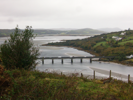 Droichead Ghaoth Beara [Gweenbarra Bridge]Bridge · 3.2 mi
Explorer Tom Droichead Ghaoth Beara [Gweenbarra Bridge] crossed the Gweebarra River in 1953 with nine main spans and a half-span at each end, replacing an older girder bridge. I need an extra finger just to count the pieces. That's a serious river crossing.
 Gweebarra BarPub · 3.2 mi
Explorer Tom Gweebarra Bar sits right on a sharp bend in the N56, waiting for someone to lose control of their vehicle. The seagulls outside are already drafting a scathing review of the interior lighting and the beer selection. Bring the dog, it will definitely have strong opinions about the décor.
 Kennedy's Bar and RestaurantRestaurant · 3.6 mi
Explorer Tom Kennedy's Bar and Restaurant is definitely hiding a secret menu involving only cabbage and regret. I bet the barman knows more about ghosts than he does about cocktails, so keep your ears peeled for whispers while you eat.
 St. Connell's Museum and Heritage CentreMuseum · 3.6 mi
Explorer Tom St. Connell's Museum and Heritage Centre lets me go from an old courtroom to the cells below, then into stories of the workhouse and Donegal railways. That is a lot of Glenties history packed into one building. I would leave the cells to the displays and keep my own visit on the friendly side of the door.
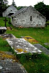 Inishkeel Graveyard near GlentiesGraveyard · 3.9 mi
Explorer Tom Inishkeel Graveyard near Glenties was rectangular in the older survey, but its south side sat on part of a roughly circular rise. Some of that rise lay beyond the west wall, about fifty metres across. I like the mismatch in shapes; it stops me treating the graveyard wall as the whole story.
 Wych Elm3.9 mi
Explorer Tom Another Wych Elm in County Donegal is having an identity crisis because all the others look the same. It's very sensitive about its bark texture. Permission slips are mandatory here. Give it a little pat on the head.
 Giant's Grave Megalithic TombMegalithic tomb · 4.2 mi
Explorer Tom Giant's Grave Megalithic Tomb lies deep in boggy ground between Aghla and Scraigs. The recorded gallery was five metres long, with six stones on each side. A slab across one end might not have been part of its original roof. That uncertainty is more interesting than pretending the wet ground offers an easy look inside.
 DooeyOfficial bathing water · 6.6 mi
Explorer Tom Dooey seems to have let the Gweebarra estuary and a headland book its two ends. Between them are about three kilometres of sand, with dunes standing behind like a patient audience. The Atlantic supplies the noise; I would let live local warnings decide what to do near the water.
More mountains and hills in County Donegal · All of County Donegal

What do you know about this place?Tap to add a comment or ask a question