
What is recorded here
Detached five-bay two-storey former school, built 1835, with pair of porches to gables. Now in use as house with later extension to rear (west). Pitched slate roofs with rendered chimneystack and cast-iron rainwater goods. Rendered walls with recessed window bands. Square-headed openings with paired two-over-two…
Read the whole record
From the Buildings of Ireland (National Inventory of Architectural Heritage) record 20914221
Places near here
Picture notes
- Computer-made picture. It does not show this monument.
- National Inventory of Architectural Heritage
- Computer-made picture. It does not show this playground.
- Aaro Koskinen, Wikimedia Commons · Attribution
- Wsiegmund, Wikimedia Commons · CC BY 2.5
- Computer-made picture. It does not show this mountain top.
- Gordon Hatton, Geograph · CC BY-SA 2.0
 IndicatedFairy fort / stone ringfort · 485 ydTom: I’m here to help · Computer-made picture. It does not show this monument.
Explorer Tom Fairy fort or stone ringfort in Maulagow (carbery East (w.d) By.), County Cork has a stone wall built atop ruins of an earlier one. The interior is heavily overgrown. It’s like a fort within a fort within a bush pile-up!
 Enclosure in Maulagow (carbery East (w.d) By.)Enclosure · 500 ydTom: I’m here to help · Computer-made picture. It does not show this monument.
Explorer Tom Enclosure in Maulagow By.), County Cork has an arc of stone-built field fence that might be the west bank. It’s on level ground with a steep drop to the NE. It’s basically a fence pretending to be a fort.
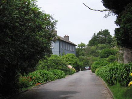 Glandore HouseHouse · 528 yd
Explorer Tom Glandore House is a big, long house that thinks it’s fancy because it’s in Glandore village. It was noted by Lewis back in 1837, so it’s been posing for photos for ages. Go take a peek and tell me if the camber-headed openings are showing off too much!
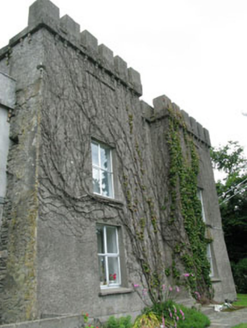 Glandore CastleCastle/fortified house · 643 yd
Explorer Tom Glandore Castle is perched up high watching the bay. It dates back to 1200, which is ancient by castle standards, and it’s been renovated since. It looks like it’s just waiting for you to walk past without asking permission. Wave!
 Walk 1 - Drombeg Standing Stone Circle (7 - 9 km)Walking route · 1398 yd
Explorer Tom Walk 1 - Drombeg Standing Stone Circle (7 - 9 km) has caught my eye in County Cork. I bet a walking route with a name like that could keep me talking all afternoon; I'm already inventing a daft little scene for it, and I'll stop before it turns into history.
Wild Atlantic WayVisitor information · 1559 ydExplorer Tom Wild Atlantic Way has caught my eye in County Cork. I bet a visitor information with a name like that could keep me talking all afternoon; I'm already inventing a daft little scene for it, and I'll stop before it turns into history.
 Children's playground1.2 miTom: I’m here to help · Computer-made picture. It does not show this playground.
Explorer Tom Children's playground has caught my eye in County Cork. I bet a children's playground with a name like that could keep me talking all afternoon; I'm already inventing a daft little scene for it, and I'll stop before it turns into history.
 Drombeg Stone CircleArchaeological place · 1.3 mi
Explorer Tom Drombeg Stone Circle has caught my eye in County Cork. I bet a archaeological place with a name like that could keep me talking all afternoon; I'm already inventing a daft little scene for it, and I'll stop before it turns into history.
 Sitka Spruce1.4 mi
Explorer Tom Another Sitka Spruce in County Cork is judging your posture from up high. Bring your worst joke, the place has heard worse and barely flinched.
 Poll na SlinneMountain / peak · 1.4 miTom: I’m here to help · Computer-made picture. It does not show this mountain top.
Explorer Tom Poll na Slinne has caught my eye in County Cork. I bet a mountain / peak with a name like that could keep me talking all afternoon; I'm already inventing a daft little scene for it, and I'll stop before it turns into history.
 CartivourneenMountain / peak · 1.5 miTom: I’m here to help · Computer-made picture. It does not show this mountain top.
Explorer Tom Cartivourneen has caught my eye in County Cork. I bet a mountain / peak with a name like that could keep me talking all afternoon; I'm already inventing a daft little scene for it, and I'll stop before it turns into history.
 Prison CoveBeach / strand · 1.6 mi
Explorer Tom Prison Cove has caught my eye in County Cork. I bet a beach / strand with a name like that could keep me talking all afternoon; I'm already inventing a daft little scene for it, and I'll stop before it turns into history.
More historic places in County Cork · All of County Cork
What do you know about this place?Tap to add a comment or ask a question