What is recorded here
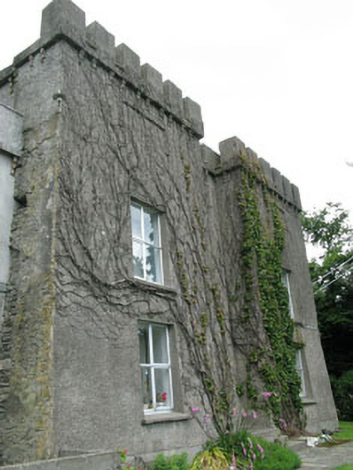
Detached former castle, built c.1200, with various later additions and alterations, and renovated c.1850. Now in use as house. Comprising three-bay two-storey crenulated entrance block having projecting end bays, with two-bay two-storey crenulated wing to south, four-stage crenulated tower to rear (west), five-bay two-storey wing to rear having gabled porch with corner turrets to north elevation, and with four-bay two-storey block to rear, attached to main building by single-bay two-storey link. Crenulated parapet conceals roof to main block and attached wing, pitched artificial slate roofs with uPVC rainwater goods to rear five-bay block, flat roof to rear four-bay block. Roughcast rendered and rubble limestone walls to main block, rendered walls to wing, rubble limestone and smooth rendered walls to five-bay rear block, rendered walls to four-bay rear block. Square-headed openings with replacement timber and uPVC windows having concrete sills. Pointed arch tripartite fixed pane timber window having stone sill to porch. Round-headed opening with two-over-six timber sliding sash window having red brick surrounds to rear. Square-headed door openings with replacement timber doors. Rubble limestone walls and outbuildings to rear.
This multiperiod dwelling represents building styles from the thirteenth century onwards. The castellated blocks and soaring tower add much to its character, while the form of the five-bay block is typical of nineteenth century two-storey houses with a centrally-located door, symmetrical fenestration and gable-end chimneystacks. The various building styles mesh well together forming an appealing structure. The building occupies an elevated site overlooking the bay.
From the Buildings of Ireland (National Inventory of Architectural Heritage) record 20914220
This does not grant access. Most recorded buildings are privately owned; view them only from public ground unless the owner allows entry.
Places near here
Photo credits
- National Inventory of Architectural Heritage
- MrCorman, Wikimedia Commons · CC BY-SA 4.0
- Wsiegmund, Wikimedia Commons · CC BY 2.5
- A.-K. D., Wikimedia Commons · CC BY-SA 4.0
- Superbass, Wikimedia Commons · CC BY-SA 4.0
- Aaro Koskinen, Wikimedia Commons · Attribution
- Gordon Hatton, Geograph · CC BY-SA 2.0
 Glandore PierPier/jetty · 129 yd
 Christ ChurchChurch/chapel · 174 ydWild Atlantic WayVisitor information · 1018 ydCooks WoodWood · 1158 ydCoastguard StationRuins · 1273 ydMyross PointHeadland · 1382 ydBig HeightMountain / peak · 1452 yd
 Sitka Spruce1.3 mi
 Fulacht fia in Drombeg (carbery E. (w.d.) By.)Fulacht fia · 1.5 mi
 Stone CircleStone circle, multiple-stone · 1.5 mi
 Drombeg Stone CircleArchaeological place · 1.5 mi
 Prison CoveBeach / strand · 1.5 mi
More historic places in County Cork · All of County Cork
What do you know about this place?