
What is recorded here
From OpenStreetMap (© OpenStreetMap contributors) w1420418921
Places near here
Photo credits
- National Inventory of Architectural Heritage
- Ian Paterson, Wikimedia Commons · CC BY-SA 2.0
- Mike Searle, Geograph · CC BY-SA 2.0
- Sitomon, Wikimedia Commons · CC BY-SA 2.0
- JP, Geograph · CC BY-SA 2.0
- Colin Park, Geograph · CC BY-SA 2.0
- jwd, Geograph · CC BY-SA 2.0
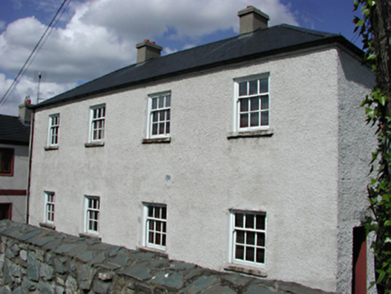 Saggart National SchoolSchool · 38 yd
Explorer Tom Saggart National School in Moneyatta Commons, County Dublin, has a handsome structure with well-maintained exterior and pleasant fenestration. It’s an attractive addition to the streetscape. If it had a dating profile, it would say 'Educated, sturdy, no drama.'
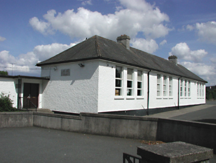 Saint Mary's National SchoolSchool · 41 yd
Explorer Tom Saint Mary's National School in Saggart is a big white building that definitely knows where all the bodies are buried. It resolutely defines itself from the smaller houses around it, which is a nice power move for a school. Spot a child running late and feel nostalgic for chaos.
Fulacht fia in Moneyatta CommonsFulacht fia · 120 ydExplorer Tom Fulacht fia in Moneyatta Commons is a badly destroyed trough filled with heat-shattered sandstones. The charcoal analysis found alder, ash, holly, and elm, so it’s got excellent taste in firewood. Have a sandwich here and call it a heritage lunch.
Font (present location) in SaggartFont (present location) · 321 ydExplorer Tom Font in Saggart. They moved this granite basin to the parochial house for safe keeping. It’s like rescuing a wet cat from the garden and putting it in the warmest room available. Good instincts, really.
Meadow WildlifeVisitor information · 1068 ydExplorer Tom Meadow Wildlife claims to have bugs and birds, which is a bold claim in Dublin. I bet there’s more pigeons than anything else, but hey, live and learn.
 Rathcoole ParkPark · 1127 yd
Explorer Tom Rathcoole Park in County Dublin has trees that remember every secret whispered beneath them. The wind carries old gossip today. Lean against a trunk and listen for the juicy details from centuries past.
Rathcoole WoodlandWood · 1340 ydExplorer Tom Rathcoole Woodland in County Dublin has a walking map nearby. The wood itself is just standing there looking confused. Take a photo if you get lost.
 CastleCastle, tower house · 3.0 mi
Explorer Tom Castle in Newcastle North is a flat-topped mound that looks like a giant’s pillow left out in the rain. It’s been sitting there since 1200, judging the church next door without saying a word. Snap one photo, then put the phone away and actually look.
 European Yew3.0 mi
Explorer Tom European Yew in County Dublin has an imaginary fan club called 'The Conifer Lovers' who meet underground. They probably argue about which branch is the most majestic and throw leaves at each other. Bring a flask of something warm and a story to swap with them.
 Grand Canal WayWalking route · 3.6 mi
Explorer Tom Grand Canal Way in County Dublin is pretending to be Kildare according to one cheeky map note. A little county peninsula poking through like a nosy neighbour. Tell me if it's still hiding!
 Cupidstown HillMountain / peak · 4.2 mi
 Griffeen Valley WalkWalking route · 4.5 mi
Explorer Tom Griffeen Valley Walk in County Dublin has a river that merges into Vesey Park, which sounds like a fancy garden party gone wrong. Grab a photo of the water for me!
More things to do in County Dublin · All of County Dublin

What do you know about this place?Tap to add a comment or ask a question