
What is recorded here
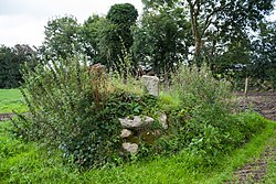
Situated on high ground with commanding views of the surrounding countryside. No surface remains visible of any round tower. OS Letters (O’Flanagan 1934, 311) record former presence of 'steeple' interpreted as round tower and association with St Molaise (holy well CW019-012----), and with St Laserian (CW019-014----).…
Read the whole record
From the National Monuments Service (Archaeological Survey of Ireland) record CW019-011002
Places near here
Photo credits
- Maker not stated on source page, commons.wikimedia.org
- liam murphy, Wikimedia Commons · CC BY-SA 2.0
- Maker not stated on source page, au.pinterest.com
- Maker not stated on source page, www.dreamstime.com
- Andreas F. Borchert, Wikimedia Commons · CC BY-SA 4.0
- liam murphy, Geograph · CC BY-SA 2.0
- Ballinkillen GAA official website; individual photographer not stated, ballinkillengaa.com
- Maker not stated on source page, www.tripadvisor.com.ph
- Maker not stated on source page, www.pinterest.com
- National Inventory of Architectural Heritage
- Maker not stated on source page, www.irishamericanmom.com
 CastleCastle, unclassified · 1 yd
Explorer Tom Castle in Lorum might have stood here, or it might be just a rumour that got written down by mistake. It has a bit of a…
 Good Shepherd Church (Lorum)Church/chapel · 272 yd
Explorer Tom Good Shepherd Church (Lorum) is Gothic Revival from 1838 with a spire that’s probably looking down on your haircut.…
 Lorum Old GraveyardCemetery · 327 yd
Explorer Tom Lorum Old Graveyard in County Carlow would absolutely throw a spanner in the works if a nosey neighbour peered over the…
 Holy well in LorumHoly well · 481 yd
Explorer Tom Holy well in Lorum is dedicated to St Lazernian, tucked away under a well house near the church. It’s got that 'I’m…
 CrossCross, High cross · 565 yd
Explorer Tom Lorum High Cross is standing on a small cairn, looking smug about it. Legend says a giant tried to move it but slipped…
 Ballinkillen GraveyardGraveyard · 1563 yd
Explorer Tom Ballinkillen Graveyard in County Carlow has been hiding a scandal so big it could only be explained by a very confused…
 Saint Lazarian's Catholic ChurchChurch/chapel · 1603 yd
Explorer Tom Saint Lazarian's Catholic Church in Ballinkillin is T-shaped, which is a weird shape for a building unless you’re…
 Ballinkillen GAA pitchGAA ground · 1652 yd
 Site of CastleCastle, unclassified · 1.0 mi
Explorer Tom Site of Castle in Ballinkillin is just a bump in the grass, which seems to have started a massive argument between…
 Fairy fort / earthen ringfort in Corries or CorrymoreFairy fort / earthen ringfort · 1.2 mi
Explorer Tom This fairy fort in Corries Or Corrymore is cut through by a field boundary because someone needed to grow potatoes more…
 Corris HouseHouse · 1.2 mi
Explorer Tom Corris House in Corries Or Corrymore is a 1730 house that’s been extended so many times it now looks like it’s been…
 Fairy fort / earthen ringfort in GormonaFairy fort / earthen ringfort · 1.3 mi
Explorer Tom Fairy fort / earthen ringfort in Gormona is posting selfies from its annexe because it thinks that makes it look more…
More archaeology and monuments in County Carlow · All of County Carlow

What do you know about this place?Tap to add a comment or ask a question