Places near here
Photo credits
- Dean Molyneaux, Wikimedia Commons · CC BY-SA 2.0
- Kenneth Allen, Geograph · CC BY-SA 2.0
- Oliver Dixon, Geograph · CC BY-SA 2.0
- Kevin Flanagan, Geograph · CC BY-SA 2.0
- National Inventory of Architectural Heritage
- Kenneth Allen, Wikimedia Commons · CC BY-SA 2.0
- Eric Jones, Geograph · CC BY-SA 2.0
- Tawg, Wikimedia Commons · CC BY-SA 3.0
- Richard Webb, Geograph · CC BY-SA 2.0
 Bridge Over Roogagh RiverBridge · 429 yd
Explorer Tom Bridge Over Roogagh River in County Fermanagh thinks it’s the only way across, which is pretty arrogant for a bridge. It probably has strict rules about who can walk on it, maybe even a dress code. Ideal for a moody photo you'll pretend wasn't posed.
 Sally IslandIslet · 1.2 mi
Explorer Tom Sally Island thinks tourists from Dublin are loud, overpriced, and smell faintly of espresso beans and bad decisions, which is why it stays quiet. It’s basically judging your outfit before you even step off the boat, wondering if you know what a proper lough is or just think it’s a lake. Hum something sad nearby, it adds atmosphere.
 Ross PointHeadland · 1.6 mi
Explorer Tom Ross Point would teach history if it had to, but it only knows how to sit there and stare at the water like a bored cat. It’s seen more ships than you’ve seen sandwiches in your entire life. Hang around long enough and you'll hear a story from a local.
 GorminishIslet · 1.7 mi
Explorer Tom Gorminish is the absolute worst guest at any wedding in Fermanagh because it just sits in the corner of Lough Melvin, looking grumpy and refusing to dance with anyone. It’s basically a tiny, stubborn rock that thinks it has more class than the Darty Mountains behind it, which is rich considering it’s barely a speck. Hum something sad nearby, it adds atmosphere.
Not indicatedHoly well · 1.9 miExplorer Tom Holy Well in Gubalaun sits by Lough Melvin, guarding a legend about a giant who was terrible at sharing his well. The pattern day is gone, but the stones still hold their breath waiting for it to return. It’s a quiet spot with a loud history hiding underneath the grass. Look serious, nod slowly, you're basically an expert now.
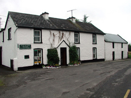 Rossinver Post OfficeHouse · 2.4 mi
Explorer Tom Rossinver Post Office is still using its original cast-iron box because it simply refuses to modernize like a stubborn grandpa. Imagine it walking into an interview saying, I have been here longer than your mortgage. Perfect detour when you need a laugh at the cost of progress.
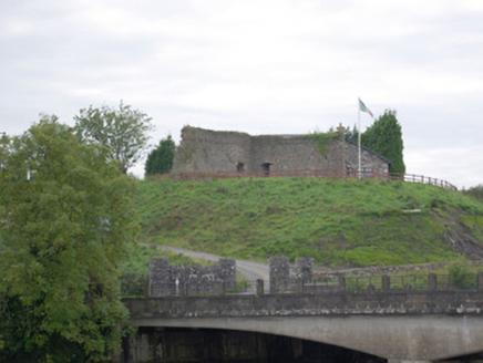 Belleek Battery / FortBattery and garrison fort · 4.2 mi
Explorer Tom Belleek Battery / Fort was raised right after the 1798 rebellion to guard the crucial bridge at Cloghgore. It’s now a battered stone mess, partly joined to someone’s private home, which is a bit cheeky of them. Those firing holes make me imagine the border guards from the 1920s staring right back.
 Belleek PotteryHeritage attraction · 4.2 mi
Explorer Tom Belleek Pottery in County Fermanagh is writing its dating profile right now: 'I make pretty blue things, I’m slightly pretentious, don’t mind.' It’s a heritage spot that thinks it’s way more fancy than a local pottery really needs to be. Bring a notebook and write the bit I made up.
 Belleek Pottery MuseumMuseum · 4.3 mi
Explorer Tom Belleek Pottery Museum in County Fermanagh refuses to fall down because it knows it has the best ceramic gossip in the entire county. It stands there on its own little hill, judging your shoe choices while you try to figure out what’s behind the door. Tell me if the gossip I made up is true.
 Battle of BelleekBattle · 4.4 mi
Explorer Tom Battle of Belleek, also called the Battle of the Erne Fords, took place at a River Erne crossing near Belleek on 10 October 1593. Hugh Maguire's defenders faced Henry Bagenal's English Crown force. I want to point at the exact ford, but that would be Tom bluffing: this marker shows the general area, and no battlefield boundary has been surveyed.
 Battlefield in Cloghore (carrickboy Ed),corlea (pettigo Ed)Battlefield · 4.8 mi
Explorer Tom Battlefield in Cloghore, Corlea refuses to fall down because it is terrified that if it does, the cows will finally take over the whole county. It holds its breath every time a tractor gets too close, sweating through its ancient earthen ramparts with pure panic. Find the wonkiest bit and send it to your group chat.
 Saddle HillMountain / peak · 5.0 mi
Explorer Tom Saddle Hill is where a fiddler played all night until his fingers turned to stone and he became part of the landscape. Locals say if you play badly enough, you’ll join him, but I think they’re just trying to stop tourists from practicing. The hill looks like it’s waiting for someone to saddle up and ride away into legend. Stand where the owner stood and practise looking smug.
More waterfalls, wells and springs in County Fermanagh · All of County Fermanagh

What do you know about this place?Tap to add a comment or ask a question