What is recorded here
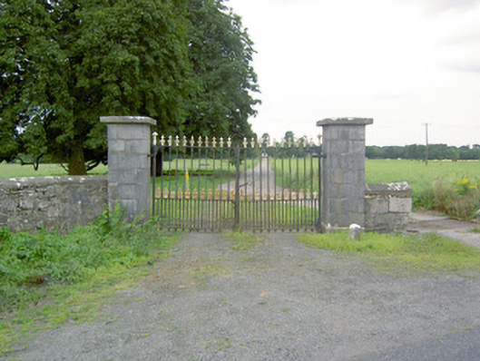
Gateway formerly serving Richfort (now demolished), built c. 1820, comprising ashlar limestone entrance piers (on square-plan) having chamfered dressed limestone plinths and tooled capstones over. Double leaf cast-iron gates. Recessed from the road and angled to face southeast. Cut stone wheel guard to the front of gate piers. Located to the east of the site of Richfort and to the northwest of Ardagh. Random rubble limestone boundary walls to road frontage to the north and the south. New gateway cut through boundary wall to the north side of gates.
This simple but well-executed gateway acts as an historic reminder of Richfort (now demolished) and is an interesting feature in the rural landscape to the northwest of Ardagh. The well-crafted ashlar limestone piers are indicative of the skill of nineteenth century craftsmanship, while the cast-iron gates are good example of their type. The gateway is positioned at an angle to the road and this arrangement may have been employed to give the entranceway the appearance of closing the vista from the southeast. A gate lodge was situated to the northwest side of the gates, now demolished (Ordnance Survey six-inch maps 1838 and 1913). This gateway was formerly the main entrance to Richfort, an estate that dates from the early-eighteenth century at the latest (the Charles Newcomen may have owned Cooleeshil or Richfort in 1732 – mortgage mentioned in his will), and it may have been leased or bought by the Richardson or Auchmuty Richardson family shortly after this (wills and deeds). It was the residence (probably leased from the Richardson family) of a John Huggins, Esq., in 1824 (Pigot’s Directory) and of a James Auchmuty Richardson, Justice of the Peace (and Grand Juror of Longford), c. 1835 (O’Donovan Letters; Lewis). Richardson also owned Richmount Hill (13402304) to the south of Ardagh c. 1840. It may have been sold in 1868 after the sale of the house was ordered by Landed Estates Court (possibly to pay debts of J. A Richardson who died in 1862). It was later the residence of a W. Raymond in 1894 (Slater’s Directory) and possibly a Rev. Irwin in 1892.
This does not grant access. Most recorded buildings are privately owned; view them only from public ground unless the owner allows entry.
Places near here
 IndicatedFairy fort / earthen ringfort · 135 yd
 sign postsign post · 1597 yd
 mill (water)mill (water) · 1600 yd
 Enclosure in MoorEnclosure · 1.0 mi
 Oldtown CopseWood · 1.2 mi
 Oldtown DemesneForest · 1.3 mi
 Ardagh DemesneFort · 1.4 mi
 Druming Ho. (in ruins)Castle, unclassified · 1.6 mi
 National Famine WayWalking route · 2.5 mi
 Graveyard in Curry (ardagh By., Coolamber Ed)Graveyard · 4.5 mi
 Saint Mel's CathedralCathedral · 4.7 mi
 First World War MemorialMemorial · 4.7 mi
Other information
Photo: National Inventory of Architectural Heritage · Website use allowed for educational or private purposes with source credit