What is recorded here
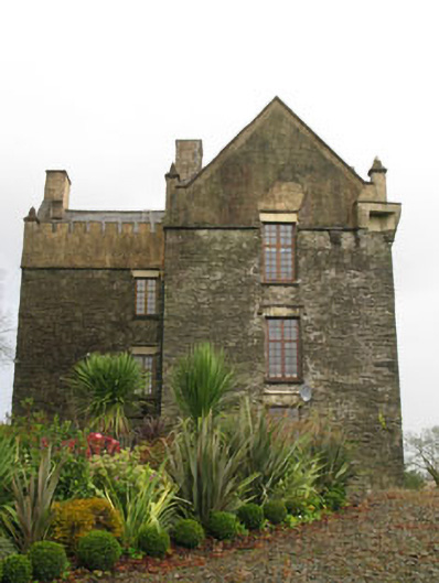
Ballea Castle stands on steep wooded cliffs above the Owenaboy River, a detached L-plan tower house built around 1680 that served as the Hodder family seat until the early 1900s. Its rubble stone walls, rendered bartizans and castellated parapets still project grandiose strength despite later alterations. The house overlooks the river like a watchful guardian, its square-headed windows and carved limestone door framing a landscape where human ambition and wild nature remain entangled.
Detached L-plan two-bay three-storey over basement fortified tower house, built c.1680, with attached flat-roofed single and two-storey castellated additions to rear (north), built c.1970. Pitched slate roofs with rendered castellated parapets, rendered gables and chimneystacks and cast-iron rainwater goods. Rubble stone walls with rendered bartizans to south-east and north-west corners and pointed finials to gabledt corners. Square-headed window openings with replacement concrete sills and limestone lintels, having some limestone label mouldings. Replacement timber casement windows. Camber-headed door opening with hollow chamfered limestone surround with carved limestone label moulding. Replacement timber battened door with cast-iron lattice gate. Rubble limestone enclosing walls with square-profile limestone gate piers on carved plinths surmounted by stepped cornice with round finials having replacement cast-iron gates.
This imposing house was the seat of the Hodder family until the early 1900s. Despite some alterations to the exterior it retains its historic form and grandiose character. Situated on steep wooded cliffs, overlooking the Owenaboy River, it is an eye-catching building in the surrounding landscape.
This does not grant access. Most recorded buildings are privately owned; view them only from public ground unless the owner allows entry.
Places near here
 Ballea CastleCastle, tower house · 66 yd
 Ballea Bridge (Upper)bridge · 313 yd
 Ballea Bridge (Lower)bridge · 455 yd
 IndicatedEnclosure · 516 yd
 Man-made underground passage in Carrigaline WestMan-made underground passage · 1228 yd
 Meadstown Castle (Site of)Castle, unclassified · 1.7 mi
 Pauper's GraveyardArchaeological place · 2.3 mi
 Graveyard in CurraghconwayGraveyard · 3.7 mi
 Be Framed Fine Art GalleryGallery · 4.0 mi
 St Laitiarain's WellSpring · 4.2 mi
 Vernon Mount ViewViewpoint · 4.3 mi
 Goat IslandIslet · 4.3 mi
Other information
Photo: National Inventory of Architectural Heritage · Website use allowed for educational or private purposes with source credit