What is recorded here
In pasture, located on a broad terrace on steep N-facing slope, giving extensive views W–N–E. This rath is named ‘Rathwanowen’ on the 1838 and 1922 OS 6-inch maps; it is shown as circular on the 1838 edition; on the 1922 edition it appears subrectangular and is incorporated into later field boundaries. It consists of…
Read the whole record
From the National Monuments Service (Archaeological Survey of Ireland) record MA015-046
Places near here
Photo credits
- Maker not stated on source page, en.wikipedia.org
- Maker not stated on source page, www.alamy.com
- Maker not stated on source page, www.gettyimages.com
- Maker not stated on source page, commons.wikimedia.org
- Maker not stated on source page, www.pinterest.com
- Maker not stated on source page, www.ibelieve.com
- National Inventory of Architectural Heritage
- Killala GAA Club, via Connaught Telegraph; individual photographer not named, www.con-telegraph.ie
 Church in KillybroneChurch · 311 yd
Explorer Tom Church in Killybrone has drama with the nearest tree. The church was demolished long ago, but the tree still stands…
 Graveyard in KillybroneGraveyard · 311 yd
Explorer Tom Graveyard in Killybrone started because two lads bet in the pub they could find a church that wasn't there. O'Donovan…
 Wedge tomb in Townplots WestWedge tomb · 667 yd
Explorer Tom Wedge tomb in Townplots West has a curse that only affects people who don't wave when they pass. If you ignore it, your…
 Church in KilgobbanChurch · 818 yd
Explorer Tom Church in Kilgobban would describe the 1800s to a teenager as 'a time when people walked everywhere and complained…
 Fairy fort / earthen ringfort in CroghanFairy fort / earthen ringfort · 1530 yd
Explorer Tom Fairy fort / earthen ringfort in Croghan is sick of being asked if it's haunted. It becomes an island at high tide, so…
 St. Patrick's GraveyardGraveyard · 1730 yd
Explorer Tom St. Patrick's Graveyard claims Queen Victoria visited once but forgot to leave any footprints or evidence whatsoever…
 CastlereaghWalled garden · 1.1 mi
Explorer Tom Castlereagh Walled Garden is a lonely brick wall that lost its big house friend in 1937 and has been sulking ever…
 Killala Railway StationStore/warehouse · 1.2 mi
Explorer Tom Killala Railway Station has a goods store involved in a feud with the next village over who had the ugliest cart in…
 Killala HouseStables · 1.2 mi
Explorer Tom Killala House has stables where a cow once tried to buy the place with three eggs and a promise. The landlord was too…
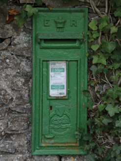 post box1.3 mi
Explorer Tom Post box in Castlereagh would tell its younger self to stop worrying. It’s just a tin can with royal initials on it.…
 CastleCastle, unclassified · 1.4 mi
Explorer Tom Two families at Rathfran are still feuding over who owns the best view of nothing in particular. It’s a castle so…
 Gerry Maheady Memorial Park, Killala GAAGAA ground · 1.4 mi
More archaeology and monuments in County Mayo · All of County Mayo

What do you know about this place?Tap to add a comment or ask a question