
What is recorded here
Map note: The map marks Pulpit Area as a cliff in County Wicklow, Ireland. Keep a sensible distance from any edge while you explore the coast.
Pulpit Area is recorded as a cliff in County Wicklow.
From OpenStreetMap (© OpenStreetMap contributors) w1317384975
Places near here
Photo credits
- David Quinn, Geograph · CC BY-SA 2.0
- National Inventory of Architectural Heritage
- 瑞丽江的河水, Wikimedia Commons · CC BY-SA 4.0
- Egita Feldberga, Wikimedia Commons · CC BY-SA 4.0
- Gareth James, Geograph · CC BY-SA 2.0
- Internet Archive identifier : jstor-30002950 https://archive.org/download/jstor-30002950/30002950.pdf IA contributor: JSTOR, Wikimedia Commons · Public domain
- Sitomon, Wikimedia Commons · CC BY-SA 2.0
Bracket SlabCliff · 48 yd Bray Greystones ViewViewpoint · 106 ydBray Greystones Cliff WalkWalking route · 562 ydStreaky SlabCliff · 677 ydBray Head HillMountain / peak · 721 ydBray Head LoopWalking route · 1333 ydRose CottageHouse · 1544 ydBray HeadMountain / peak · 1.1 miKilrudderyHouse, 16th/17th century · 1.3 miBray BeachBeach / strand · 2.0 miOldcourt CastleCastle · 2.1 miEuropean Yew2.5 mi
 Bray Greystones ViewViewpoint · 106 ydBray Greystones Cliff WalkWalking route · 562 ydStreaky SlabCliff · 677 yd
 Bray Head HillMountain / peak · 721 ydBray Head LoopWalking route · 1333 yd
 Rose CottageHouse · 1544 yd
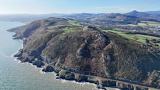 Bray HeadMountain / peak · 1.1 mi
 KilrudderyHouse, 16th/17th century · 1.3 mi
 Bray BeachBeach / strand · 2.0 mi
 Oldcourt CastleCastle · 2.1 mi
 European Yew2.5 mi
More cliffs, bays and coast in County Wicklow · All of County Wicklow

What do you know about this place?Tap to add a comment or ask a question