
Places near here
Photo credits
- Kenneth Allen, Wikimedia Commons · CC BY-SA 2.0
- National Inventory of Architectural Heritage
- Corinna Schleiffer, Wikimedia Commons · CC BY-SA 2.0
- danny kearney, Wikimedia Commons · CC BY-SA 2.0
- Kenneth Allen, Geograph · CC BY-SA 2.0
- Oliver Dixon, Wikimedia Commons · CC BY-SA 2.0
- Attila Terbócs, Wikimedia Commons · CC BY-SA 3.0
- DAYVEHUSE, Wikimedia Commons · CC BY-SA 4.0
- Picture: Simpson's Bar & Restaurant
- Picture: Barrack Hill Town Park
 CroaghmoreMountain / peak · 866 yd
Explorer Tom Croaghmore in County Donegal would win a county fair easily, simply by standing still and looking vaguely impressive while everything else tries too hard. It’s the kind of hill that wins prizes without even entering them, just by existing so grandly. Visit, then text me what you think. I'll pretend to read it.
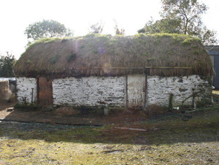 outbuilding1.9 mi
Explorer Tom Outbuilding in Ballyargus is a c. 1860 survivor with whitewashed random rubble walls that look like a daft patchwork quilt. It’s a rare, humble spot where timber battened doors still swing shut on a simple life, proving that even the boring shed can hold some serious local character.
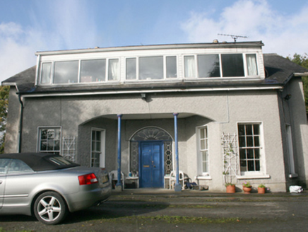 Foyle ViewHouse · 2.3 mi
Explorer Tom Foyle View was actually called Castle View on the 1837 maps, which sounds grander but this place is still a beauty. Those canted bays flanking the recessed porch are an unusual touch that really sets it apart from its neighbours. The decorative glazing bars in the fanlight just add to the charm.
 CrockavishaneMountain / peak · 2.6 mi
Explorer Tom Crockavishane in Donegal is having a very fancy lunch experience that costs nothing but your dignity. It’s all about the ambiance of doing absolutely nothing productive. Have a sandwich here and call it a heritage lunch.
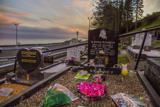 Drung GraveyardBurial ground · 2.6 mi
Explorer Tom Drung Graveyard sits on a plateau above Lough Foyle, hiding the ghost of an old ringfort. The earthworks are mostly gone under the headstones, leaving just faint curves to the north and east. It’s a layer cake of history that time has flattened out.
 Orchard BarPub · 3.8 mi
Explorer Tom Orchard Bar in County Donegal has an unlikely celebrity friend who only visits when the cider is fresh. I’d bet they keep a secret orchard just for their own private boozy harvest. Wave at the cows, they're the real locals.
 Old CrossCross, High cross · 4.3 mi
Explorer Tom Old Cross is a stark, undecorated ringed cross standing guard outside the graveyard. It’s over two and a half metres tall but completely plain, which makes it feel like a silent sentinel watching over St. Patrick’s ancient foundations.
 Cooley CrossMemorial · 4.3 mi
Explorer Tom Cooley Cross hosted a dance that went so wild that someone actually broke a fence, and they still blame the cross for it. The locals say the stone vibrated with the bass, which is either true or a very good story. Stand where the owner stood and practise looking smug.
 Cooly GraveyardGraveyard · 4.3 mi
Explorer Tom Cooly Graveyard held an unusual find during a cleanup in 2010: half a millstone near the east wall. The record says it may have served as a headstone; its original mill has not been located either. I love that one stone brings two questions here, but neither possibility is certain.
 Quigley's PointHeadland · 4.4 mi
Explorer Tom Near Quigley's Point, United States Navy seaplanes flew from a Lough Foyle base in 1918. It closed by February 1919, after crews had built roads, hangars and slipways; quite a lot of building for such a short stay.
 Simpson's Bar & RestaurantPub · 5.3 mi
Explorer Tom Simpson's Bar & Restaurant in Carndonagh has a fairy dispute over parking rights that’s getting silly. Grab a drink before they realize you're actually lost and not just exploring. Bring a pen pal, they'll be jealous.
 Barrack Hill Community GardensGarden · 5.4 mi
Explorer Tom Follow the growers on Barrack Hill and you will find sixteen raised beds and three polytunnels. One starts the seedlings; the other two keep things growing. I could claim to know their secret for a good tomato, but the gardeners would catch me bluffing before I got through the gate. These are working plots, so ask the committee before going in.
More mountains and hills in County Donegal · All of County Donegal

What do you know about this place?Tap to add a comment or ask a question