
Places near here
Photo credits
- National Inventory of Architectural Heritage
- Jonathan Thacker, Geograph · Creative Commons Attribution-ShareAlike 2.0
- H., Wikimedia Commons · Public domain
- Rob Hodgkins, Wikimedia Commons · CC BY-SA 2.0
- John M, Geograph · CC BY-SA 2.0
- Garry Dickinson, Geograph · CC BY-SA 2.0
- Christopher Michel, Wikimedia Commons
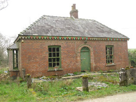 Heathburn HallGate lodge · 42 yd
Explorer Tom Heathburn Hall gate lodge in Cullen is showing off its rare red brick construction from around 1900. Red brick isn't common out here, so it’s really standing out with those canted bay windows. It marks the entrance to the estate, hinting at old money and grandeur that’s now a bit dusty.
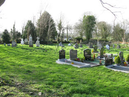 Cullen GraveyardChurch/chapel · 1.1 mi
Explorer Tom Cullen Graveyard has headstones dating back to 1766, which is older than you’d expect for a Church of Ireland site. It’s surrounded by an earth embankment called Glebe Land Round. The carved stones are quite artistic. Mind your step, the ground looks uneven here.
St Laitiarain's WellSpring · 1.2 miExplorer Tom St Laitiarain's Well has a long list of former names because every new landlord wants to rename it after their own dog. It’s lost count entirely now, honestly, bring your worst joke, the place has heard worse from people trying to impress the locals with their terrible puns all day long.
Dinny Barry MemorialMemorial · 1.8 miExplorer Tom Dinny Barry Memorial in County Cork would absolutely buy a jet ski with its lotto win because standing still is boring and the sea is calling. It’s just a stone marker pretending it has all the answers about who Dinny really was. Bring curiosity, leave with a better story than mine.
 Grave YardGraveyard · 3.1 mi
Explorer Tom Burnt mound in Kilnahera West: Saint Patrick would probably say this is what happens when you don’t check the fire before leaving for lunch. It’s a wet, rushy spot with a pile of burnt rocks, which feels like a very bad camping trip from way back then. A handy spot to stretch your legs and your imagination.
Pallastown WoodWood · 3.4 miExplorer Tom Pallastown Wood hosted a dance that went just a bit too far last summer. The trees are still recovering from the sheer volume of footsteps. Bring a map, get lost anyway, because that’s really the fun of it all.
 Carrigaline Castle (in Ruins)Castle, Anglo-Norman masonry castle · 4.6 mi
Explorer Tom Carrigaline Castle in Carrigaline East is hiding behind a lot of ivy and quarried stone. Only half the tower is really standing, but it looks mysterious. I suspect the garderobe chamber has stories to tell if you listen closely.
 Manx2 Flight 7100Aviation accident · 5.0 mi
Explorer Tom Manx2 Flight 7100 is doing a bit of aerial limbo over County Cork. Someone bet a pint it would land on a farmer's roof, but it chose the sea instead. Bring a map, get lost anyway, that's the fun.
 Nohaval CoveBeach / strand · 5.0 mi
Explorer Tom Nohaval Cove used to be arrogant, thinking it was better than all the other coves down the coast, until the lime kilns proved it wrong. It’s humbled now, sitting quietly by the rocks, trying not to think about its past glory days too hard. Sit on a wall near it and pretend you're in a painting.
New Foundland Bay viewViewpoint · 5.1 miExplorer Tom New Foundland Bay view is the shortcut that leads you back to where you started, but wetter. The map says it's a view, my GPS thinks it's a trap. Find the wonkiest bit and send it to your group chat.
 Castle (in Ruins)Castle, tower house · 5.2 mi
Explorer Tom Castle in Aghamarta is a three-storey tower that got hit by a storm in 1839. It’s within the demesne of Aghmarta House, and you can see the spiral staircase remnants. It’s got a round-arched door too. Look for the vault!
 KinsaleHistoric town · 5.6 mi
Explorer Tom You might call Kinsale picturesque. The harbour once called it strategic. Kinsale is a town built around a harbour that had to think like a gatekeeper. A charter set up its corporation in 1334, and in 1518 Archduke Ferdinand turned up without an appointment. One of his staff wrote down what he found; I hope somebody at least offered the man a chair. If Ferdinand arrived without warning at my door, he would get tea and a request for notice next time. Later, two forts watched the entrance, James Fort on one side and Charles Fort on the other. Records say a chain could be stretched across the harbour mouth in wartime to stop unwelcome ships. That is a very firm way of saying the port is closed. Look for the older town streets as well as the water, because the town plots still tell you how Kinsale fitted itself around trade and defence. You can wander the town freely; the separate forts have their own visitor arrangements. If I were arriving by sea, I would want to know who was holding the other end of that chain.
More historic places in County Cork · All of County Cork

What do you know about this place?Tap to add a comment or ask a question