
Places near here
Photo credits
- National Inventory of Architectural Heritage
- RonanMcCormick, Wikimedia Commons · CC BY-SA 4.0
- Didier Descouens, Wikimedia Commons · CC BY-SA 4.0
- Bob Embleton, Geograph · CC BY-SA 2.0
- Bill Griffiths, Wikimedia Commons · CC BY-SA 2.0
- Haydn Hammerton, Wikimedia Commons · CC BY-SA 4.0
- Nigel Thompson, Geograph · CC BY-SA 2.0
- Mark Duncan, Geograph · CC BY-SA 2.0
Explorer Tom Forts in Derver would order double chips and gravy at the chipper because it’s got too much history to be dieting. The mound is huge and has been dug into so much it looks like a giant trampoline for local kids. Tell me if the gossip I made up is true.
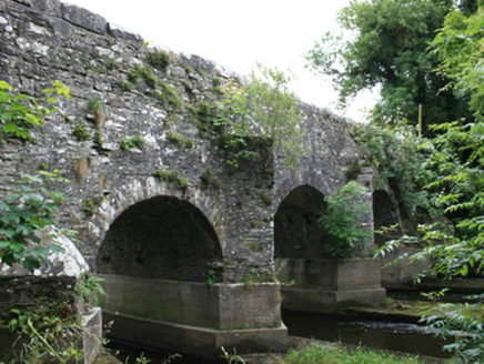 O'Daly's BridgeBridge · 1445 yd
Explorer Tom O'Daly's Bridge spans the border with stepped cutwaters that look like they're trying to climb out of the river. It's got an inscribed date stone, so it knows exactly how old it is and isn't impressed by you. Bring a notebook to write down its complaints!
 bridge1677 yd
Explorer Tom Bridge in Pottlereagh goes clack-clack at night like a ghost doing its best impression of a train. It’s got that old railway swagger baked right into the brick. Sit on a wall near it and pretend you own the place.
Woodpole Fox CovertWood · 1.1 mi CrossCross, High cross · 2.3 mi
Explorer Tom Cross in Castlekeeran is guarded by a dog who demands a biscuit before you even blink. The interlace is basically just squiggles if you look hard enough. Great spot to propose. Or at least to propose lunch.
 Hawthorn2.3 mi
Explorer Tom Hawthorn in Meath has thorns sharp enough to survive any zombie attack without breaking a sweat. It’s the ultimate defense mechanism, looking prickly but actually quite welcoming if you’re brave enough. Stand still and listen, the wind tells it better than me.
 Grave YardGraveyard · 2.3 mi
Explorer Tom Graveyard in Castlekeeran would bring a Viking helmet to any party just to keep people on their toes. It’s seen looters twice and still stands there with three high crosses looking like they’re judging your outfit. Best seen with a hangover and a sausage roll.
 Earthen TumulusCastle, motte · 4.0 mi
Explorer Tom Earthen Tumulus in Patrickstown inspired a bad poem about a fairy queen who was actually just a very confused farmer. It’s been quarried at the top because someone needed gravel for their driveway centuries ago. Make a wish, it's had centuries of practice.
 Slieve Na CalliaghMountain / peak · 5.1 mi
Explorer Tom Slieve na Calliagh is Meath's highest hill at 276 metres, but its real claim is the crowd of ancient tombs along the tops. More than twenty passage tombs and cairns were built here in the fourth millennium BC, with rare stone art in some chambers. Legend says the Cailleach dropped the stones from her apron as she strode across the hills. I would try that trick, but my apron barely holds lunch. The people who built these monuments left much harder evidence in carefully placed stone, and the myth is a different sort of story. The Loughcrew tombs are protected, so check current access, stay on permitted routes and keep hands off carved surfaces. The hills include Carnbane East and West, not just one neat summit. Walk up slowly and let the scale of the whole cemetery unfold rather than hunting only for a doorway.
 Loughcrew Megalithic TombsHeritage attraction · 5.2 mi
Explorer Tom You wanted one tomb? Loughcrew has sent you uphill for more than thirty. Loughcrew spreads its ancient monuments over four hilltops, which is a lot of climbing for anyone expecting one convenient stone circle. More than thirty tomb remains lie here, many decorated with circles, lozenges and leaf shapes cut into local gritstone. At Cairn T the rising sun around the spring and autumn equinox can reach into the chamber and light the carvings, a trick that took planning and a good deal of faith in Irish mornings. I'd ask the Cailleach for directions, but legends are rarely good at marking paths. Legend says the Cailleach dropped the stones from her apron as she crossed the hills; archaeology has a longer and less tidy account of people building here around 3300 BC. The hilltops are exposed walking ground, and access inside monuments can be restricted, so check current heritage arrangements and respect closures. Bring your own legs for the climb and leave every carved stone exactly where its builders put it.
 Kells Round TowerMemorial · 5.3 mi
 Kells High Crosses and Round TowerMemorial · 5.3 mi
More archaeology and monuments in County Meath · All of County Meath

What do you know about this place?Tap to add a comment or ask a question