Places near here
Photo credits
- National Inventory of Architectural Heritage
- Jelena.dublin, Wikimedia Commons · CC BY-SA 4.0
- Harold Strong, Geograph · CC BY-SA 2.0
- Mike Searle, Wikimedia Commons · CC BY-SA 2.0
- TeaTimeJ, Wikimedia Commons · CC BY-SA 4.0
- Rob Hurson, Wikimedia Commons · CC BY-SA 4.0
- JP, Wikimedia Commons · CC BY-SA 2.0
- Laurel Lodged, Wikimedia Commons · CC BY-SA 4.0
- Peter Gerken, Geograph · CC BY-SA 2.0
- Mike Murphy ( talk · contribs ), Wikimedia Commons · CC BY-SA 3.0
- Smirkybec, Wikimedia Commons
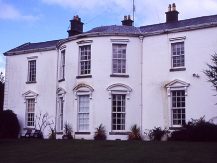 HollywoodrathCountry house · 927 yd
Explorer Tom Hollywoodrath is a big country house from 1830 with an Ionic portico. It’s got that grand, 'look at me' energy. Bet the ghosts in there have better shoes than we do. Snap one for me!
_-_20210928183406.jpg/250px-County_Dublin_-_St_Thomas's_Church_(Hollystown)_-_20210928183406.jpg "Photo: Jelena.dublin, Wikimedia Commons · CC BY-SA 4.0") Saint Thomas's Church (Mulhuddart)Church/chapel · 1548 yd
Saint Thomas's Church (Mulhuddart)Church/chapel · 1548 ydExplorer Tom Saint Thomas’s Church in Hollystown is currently in a heated fairy dispute over who gets to park their tiny wagons on the churchyard lawn. The turrets are octagonal, which means the fairies have plenty of corners to hide their arguments from us. Go with someone who loves old stuff and watch them melt.
 TyrrelstownWood · 1.6 mi
Explorer Tom Tyrrelstown had a moment where a fox took charge of the whole operation and decided it was the new king of the hill. Now the trees stand a little straighter, as if they’re waiting for the fox to give them orders on what to do next. Go with someone who loves old stuff and watch them melt into a puddle of pure, unadulterated nostalgia right
.jpg/250px-Castles_of_Leinster-_Dunsoghly,_Co._Dublin_(geograph_2496350).jpg "Photo: Mike Searle, Wikimedia Commons · CC BY-SA 2.0") CastleCastle, tower house · 1.7 mi
CastleCastle, tower house · 1.7 miExplorer Tom Dunsoghly Castle once had a massive feud with the next village over whose potatoes were tastier, and honestly, we never settled who was right. It stands there with four corner towers like it’s ready to defend its opinion with stone force. Bring a map, get lost anyway, that's the fun.
 Graveyard in BuzzardstownGraveyard · 1.7 mi
Explorer Tom Graveyard in Buzzardstown has strict visitor rules: no touching the reused architectural fragments or they’ll bite you, which is probably just my imagination being overly dramatic. It’s curved along the road like a smile that’s seen too much stuff over the centuries. Stop the car, it's worth the hazard lights.
 Ladys WellHoly well · 1.9 mi
Explorer Tom Ladys Well in Tyrrelstown is dedicated to the Blessed Virgin Mary, but it looks more like a stone shrine that got tired of being pious and started posing instead. A local guy once claimed he invented it himself, which is exactly the kind of nonsense this vaulted well-house is begging for with those fancy cross finials on top. Bring a jacket, it's never as warm as I promise.
 MoatMound · 2.0 mi
Explorer Tom Moat in Corduff is completely covered in brambles, looking like a giant green hedge that’s been left out in the rain for centuries. Rumour has it a cow tried to buy it once but got tangled up in the overgrowth and had to run away. Snap one photo, then put the phone away and actually look.
 Dunsink ObservatoryHeritage attraction · 2.8 mi
Explorer Tom Dunsink Observatory reminds me that a good walk can produce more than sore feet. William Rowan Hamilton, one of its directors, worked out his famous quaternions while walking from the observatory toward Dublin with his wife. I would walk the same route and discover only where to buy lunch. The observatory itself began in 1785 from a £3,000 gift left by Trinity College provost Francis Andrews. Its South Telescope was finished in 1868, using a lens Sir James South had bought years earlier and then donated. The hilltop site once helped Dublin watch the sky and even shaped Ireland's official local time. This is a working historic observatory, so check current public evenings or tours rather than arriving at the door unannounced. Stand outside and look up first. The stars have kept their appointment even when visitors need to book.
 Castleknock CastleCastle · 4.1 mi
Explorer Tom Castleknock Castle in County Dublin has a New Year's resolution to stop leaning so much to the left. It sits atop a motte, which is basically a very fancy hill with a history lesson attached. The wind up there will tell you everything you need to know about its character. Toast it with a cup of tea and move on to the next.
 BallymunVisitor information · 4.3 mi
Explorer Tom Ballymun in County Dublin is currently in a fairy dispute over parking rights, which explains why every car is slightly crooked and confused. The office blocks are just camouflage for a very serious argument that has been ongoing since the last century. Get a photo with it before it gets a better agent.
 Giant Sequoia4.7 mi
Explorer Tom Giant Sequoia in County Dublin would win any county fair easily just by standing there and looking like it ate an entire forest for breakfast. It’s the kind of big that makes your car look like a toy in a toy shop. Best enjoyed with a bag of chips and no plans.
 Albert College ParkPark · 5.0 mi
Explorer Tom Albert College Park began as a teaching farm, so I could walk through it and pretend I was studying very hard for an exam in grass. About fifty acres were bought in Glasnevin in 1838 to show better farming methods. Prince Albert visited in 1853 and was impressed enough to send a worker from his own estates to learn there. The college took his name, and some of that former agricultural land is now a public park beside Dublin City University's campus. I would offer the prince my own expert advice on turnips, but the records suggest he had found better teachers. Use the public gates, check current opening and share the paths. Look across the lawns with the old fields in mind. A lesson farm became a place for everybody to take a breath.
More archaeology and monuments in County Dublin · All of County Dublin

What do you know about this place?Tap to add a comment or ask a question