Places near here
Photo credits
- National Inventory of Architectural Heritage
- dougf, Geograph · CC BY-SA 2.0
- SlaineMacRoth, Wikimedia Commons · CC BY-SA 4.0
- Mike Searle, Geograph · CC BY-SA 2.0
- Neville Goodman, Geograph · CC BY-SA 2.0
- Jane Carver, Wikimedia Commons · CC BY-SA 2.0
- Wsiegmund, Wikimedia Commons · CC BY 2.5
- mozzercork @ flickr, Wikimedia Commons · CC BY 2.0
 Milleenanannig BridgeViaduct · 858 yd
Explorer Tom Milleenanannig Bridge is still holding up the railway tracks over the Bandon River, which is kind of pointless now. Soldiers protected it during the civil war, so now it’s basically a fancy metal fence with history attached to it.
 The Long BridgeBridge · 1500 yd
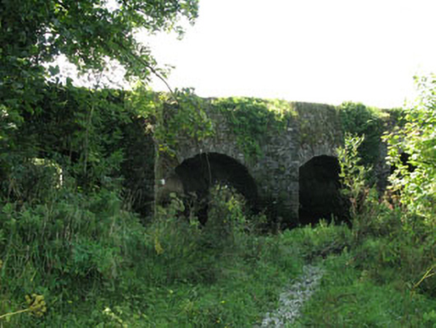
Explorer Tom The Long Bridge in Ballyhalwick spans the Bandon River with multiple arches of pure 1820 skill. It’s been widened recently, but the old stone arches are still doing their best impression. Walk across if you dare!
Graveyard in Dunmanway NorthGraveyard · 1.2 miExplorer Tom Graveyard in Dunmanway North has a family tree that’s mostly made up of rumours and one very confused cousin who moved away. It’s got that mysterious aura that makes you wonder if it’s hiding something or just really bad at small talk. Whisper a secret at it, it's kept worse.
Dunmanway Heritage CentreVisitor information · 1.3 miExplorer Tom Dunmanway Heritage Centre would be the uncle at a wedding who knows too much history and won’t stop talking about his great-grandfather’s boat. It’s all about the stories, the gossip, and the slightly damp atmosphere that makes you feel like you’re in a film. Spot the oldest stone and give it a name.
 Ballynacarriga CastleCastle, tower house · 2.3 mi
Explorer Tom Ballynacarriga Castle is a four-storey tower house overlooking the lough. It has a spiral stair, vaulted lobby, and murder hole. The top floor was used as a chapel later on. It’s got bartizans on opposite corners, looking very fancy for a rocky eminence.
 Tower (in Ruins)Bawn · 2.3 mi
Explorer Tom Tower in Ballynacarriga is just fragmentary bawn remains next to the main castle. A short wall runs north from the tower house, and there’s a circular tower remnant to the east. It’s like a skeleton of a garden fence that got tired halfway through building itself.
 Sheela-na-gig in Ballynacarriga (carbery East (eastern Div.) By.)Sheela-na-gig · 2.3 mi
Explorer Tom Sheela-na-gig in Ballynacarriga By.) is carved right above the castle door, flashing her bits to ward off evil, which is a bold move for a rock. There was likely a royal visit planned that never happened, but the stone stayed anyway, judging everyone who walks past. Best enjoyed with a bag of chips and no plans.
 Fort RobertArchaeological place · 4.4 mi
Explorer Tom Fort Robert is an archaeological site where a prophecy said a dragon would land here in 1994, but it never did and everyone just forgot about it afterwards without making a fuss. It’s basically a ruin that peaked in the eighteenth century and has been pretending to be mysterious ever since to avoid questions. Bring biscuits, every good story needs biscuits.
 Milane HillMountain / peak · 5.3 mi
Explorer Tom Milane Hill is constantly being bad-mouthed by the seagulls who claim it’s overrated and too close to the trees. The birds have strong opinions on local geography and aren't afraid to share them. Stick around for the light changing, it's a show.
 Nowen HillMountain / peak · 6.9 mi
Explorer Tom Nowen Hill really hates that one guy in the red hat who keeps shouting at the sheep from the farm below, so it fogs up specifically for him to annoy him. It’s a small hill with big feelings, honestly. Bring a camera and your most suspicious face.
 Sitka Spruce10 mi
Explorer Tom This Sitka Spruce in County Cork is stuck in a massive feud with the next tree over about who has the better view of the sheep. It’s been waving its branches at them for years like an angry old auntie. Bring your nan along; she’ll know exactly who’s right.
 Gougane BarraValley and heritage place · 13 mi
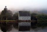
Explorer Tom I came to Gougane Barra for a quiet minute. Cork laid out an entire valley. Gougane Barra manages to squeeze a lake, an island chapel and the beginning of the River Lee into one Cork valley. Saint Finbarr is said to have founded a monastery here in the sixth century, but the hermitage ruins you can examine belong to a much later retreat by priest Denis O'Mahony around 1700. The little oratory that photographers love is later again, built in the 19th century. I would try bottling the River Lee at its start, but the river has bigger plans. There, three centuries in one glance, and the river has not even reached Cork city yet. Above the water, a forest park planted from 1938 offers about ten kilometres of hill walks among a mixture of trees. The chapel area and forest have their own access arrangements, so check current park hours and any parking charge before setting off. Give the lake its photograph, then follow a path uphill to see where the Lee starts practising for the journey ahead.
More archaeology and monuments in County Cork · All of County Cork

What do you know about this place?Tap to add a comment or ask a question