Places near here
Photo credits
- Mike Searle, Geograph · CC BY-SA 2.0
- National Inventory of Architectural Heritage
- Cantoo, Geograph · CC BY-SA 2.0
- Sitomon, Wikimedia Commons · CC BY-SA 2.0
- Mike Searle, Wikimedia Commons · CC BY-SA 2.0
- Unknown author Unknown author, Wikimedia Commons · Public domain
Explorer Tom A field system in Ballycushen is just cropmarks seen from above, so you need an aeroplane or very good binoculars to see the rectangles. It’s a fragmented pattern that looks like someone drew boxes on the ground and then forgot. Stop the car, it's worth the hazard lights if you can spot them.
Enclosure in BallycushenEnclosure · 585 ydExplorer Tom Enclosure in Ballycushen is just a cropmark on the ground, invisible to the naked eye but very smug about it. The seagulls probably laugh at it for being so hard to find and see. Find a local nearby and ask them the real story, then come back and tell me.
 Kilmaclenine CastleCastle · 1.4 mi
Explorer Tom Kilmaclenine Castle in County Cork is basically a rectangular court with no walls, which makes me think the builders gave up halfway through. Maybe they went out for lunch and never came back. Check the corners.
 gate lodge1.4 mi
Explorer Tom Gate lodge in Lisleagh has got peck-dressed quoins that look like they were chiselled by a very angry sculptor. It’s disused but stands proud on the road. Wave to the decorative gates if they’re still hanging there.
 Ard na GréineHouse · 1.9 mi
Explorer Tom Ard na Gréine means 'Place of the Sun', but this Ballyclogh house looks like it’s napping in the shade. Built in 1880, it’s got timber sash windows that just stare at you. Say cheese for me!
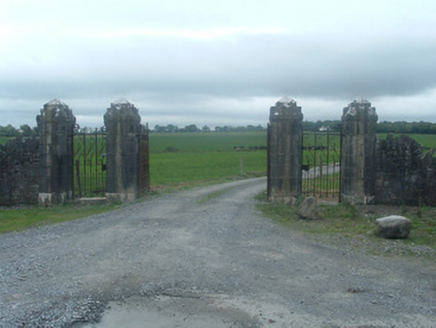 CastlelohortGates/railings/walls · 1.9 mi
Explorer Tom Castlelohort gates are showing off their ironwork like they won a beauty pageant. The limestone piers look fancy, but I bet the gatekeeper is just a very serious owl. Take the picture and tell them Tom said hi!
 CastleBawn · 1.9 mi
Explorer Tom Castle bawn in Ballyclogh had a bishop who refused to visit because he didn't like the way the walls were aligned with the sun and the stars. It is just a square enclosure now, but it still feels like it's judging your parking skills from every corner of the perimeter. Bring biscuits, every good story needs biscuits.
Graveyard in Ballygiblin (duhallow By.)Graveyard · 2.3 miExplorer Tom Graveyard in Ballygiblin got bulldozed for quarrying, which is basically nature’s way of saying 'move along'. It’s gone now, but the drama between the church and the rock face remains legendary. Perfect place to be dramatically windswept.
 European Yew3.8 mi
Explorer Tom European Yew here, planning retirement by just standing still for another five hundred years. It says it's saving up leaves for a big trip to the afterlife. Stick around for the light changing, it's a slow burn show.
Burial ground in AssolasBurial ground · 4.1 miExplorer Tom Burial ground in Assolas, County Cork, is just a dip in the ground with no markers, which is very polite for a place full of dead soldiers. Stand on the spot and imagine the gossip it's heard.
 Dromaneen CastleHeritage attraction · 4.8 mi
Explorer Tom Dromaneen Castle in County Cork is hidden by trees because the map makers were too lazy to walk the extra ten yards to check it out. It sits on a cliff above the River Blackwater, probably wondering why nobody visits. Bring the dog, it'll have opinions about the moss.
 Battle of LiscarrollMajor battlefield · 4.9 mi
Explorer Tom Battle of Liscarroll in County Cork is where two armies had a massive row in 1642, and honestly, I think they just wanted different chips at the chippy. Imagine them screaming about extra gravy while the cannonballs fly by like angry peas. Have a look and decide if I was lying.
More archaeology and monuments in County Cork · All of County Cork

What do you know about this place?Tap to add a comment or ask a question