What is recorded here
Situated on high ground with commanding views of the surrounding countryside. Rectangular shaped area (approx. dims. 50m E-W; 30m N-S) enclosed by a post-medieval stone wall with entrance gates at E and W. Graveyard contains memorials mainly dating from the 18th and 19th centuries. Church ruins (CW019-011001-) stand…
Read the whole record
From the National Monuments Service (Archaeological Survey of Ireland) record CW019-011004
Places near here
Picture notes
- liam murphy, Wikimedia Commons · CC BY-SA 2.0
- Andreas F. Borchert, Wikimedia Commons · CC BY-SA 4.0
- liam murphy, Geograph · CC BY-SA 2.0
- VisionsofthePast, Wikimedia Commons · CC BY-SA 4.0
- Wanfried-Dublin, Wikimedia Commons · CC BY-SA 4.0
- Ronnie Nijboer, Wikimedia Commons · CC0
- Poleary91, Wikimedia Commons · CC BY-SA 4.0
- Computer-made picture. It does not show this playground.
- A.-K. D., Wikimedia Commons · CC BY-SA 4.0
- A.-K. D., Wikimedia Commons · CC0
- Zapp111, Wikimedia Commons · CC BY-SA 4.0
 Good Shepherd Church (Lorum)Church/chapel · 55 yd
Explorer Tom Good Shepherd Church is now ruins, but it once had stained glass and a broach spire, designed by Frederick Darley for the parish.
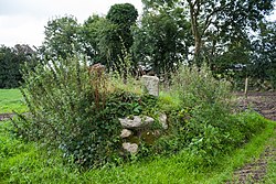 CrossCross, High cross · 246 yd
Explorer Tom A portion of a narrow granite shaft stands on a small cairn at Lorum, with faintly outlined panels visible on its eastern face.
 Saint Lazarian's Catholic ChurchChurch/chapel · 1710 yd
Explorer Tom I wonder about the timber Ionic former reredos inside Saint Lazarian's Catholic Church, sitting quietly in Ballinkillin since 1793.
 Ballyloughan Castle (in ruins)Castle, Anglo-Norman masonry castle · 1.4 mi
Explorer Tom Ballyloughan Castle is a late thirteenth-century fortress with a double-towered gatehouse, standing as a significant historical monument in this region.
 Cloghabrona Druids AltarPortal tomb · 2.0 mi
Explorer Tom Cloghabrona Druids Altar features a massive capstone resting on a collapsed chamber, inviting you to imagine ancient rituals.
 Wych Elm2.1 mi
Explorer Tom This Wych Elm stands with quiet dignity, likely remembering every single season that has passed over County Carlow recently.
 Ballymoon Castle (in ruins)Castle, Anglo-Norman masonry castle · 2.7 mi
Explorer Tom Ballymoon Castle in County Carlow is doing a bit of a disappearing act for you. Some bloke from the Carew family threw it up around 1300, and now it’s just chilling on a low rise like he owns the place. Give that square courtyard a proper wave!
 Children's playground2.7 miComputer-made picture. It does not show this playground.
Explorer Tom Children's playground in County Carlow is playing hide-and-seek with me. I heard the slide is made of pure rainbow glass, but it might just be very shiny plastic that needs cleaning.
 The Columban WayVisitor information · 2.9 mi
Explorer Tom The Columban Way in Bagenalstown, County Carlow, marks a key point on this historic route through the Irish countryside.
 Kiddies KingdomChildren's playground · 3.1 miComputer-made picture. It does not show this playground.
Explorer Tom Kiddies Kingdom in County Carlow sounds like a tiny realm of pure, unadulterated magical fun for the young.
 Lock Keeper's House and Lodge MillsVisitor information · 3.2 mi
Explorer Tom The Lock Keeper's House and Lodge Mills in County Carlow showcase the River Barrow’s 18th-century industrial legacy.
 Church (in ruins), GraveyardChurch · 3.4 mi
Explorer Tom The Wells parish church, referenced back in 1262, retains its divided nave and chancel structure within the southwest sector of its graveyard.
More archaeology and monuments in County Carlow · All of County Carlow

What do you know about this place?Tap to add a comment or ask a question