Places near here
Photo credits
- National Inventory of Architectural Heritage
- Mike Searle, Wikimedia Commons · CC BY-SA 2.0
- Mike Searle, Geograph · CC BY-SA 2.0
- Frabjousone, Wikimedia Commons · CC BY-SA 4.0
- Maker named on the Wikimedia Commons picture page · Public domain
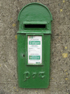 post box36 yd
Explorer Tom Post box in Murragh has artistic lettering that makes it look like a Victorian fashionista. The rain has a long grudge against its shiny surface, though. Go on, give it a little pat before you leave!
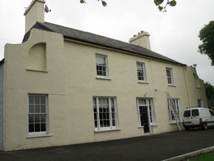 LakemountHouse · 461 yd
Explorer Tom Lakemount in Dromavane was built for £500 in 1813, which probably meant the builder got paid in cheese and promises. The cobbled courtyard is perfect for dropping a coin and wishing for better life choices. Linger, it’s not going anywhere unless the goats decide to migrate.
Tobar MacloonaboySpring · 2.2 miExplorer Tom Tobar Macloonaboy makes a weird bubbling sound at night that sounds suspiciously like it’s laughing at your life choices. I could swear I heard a giggle last week. Tell me if the gossip I made up is true.
The GlenWood · 2.6 miExplorer Tom The Glen in County Cork is having a bit of a midlife crisis, whispering to the trees that replaced it that they're all just fancy shrubs with delusions of grandeur. It's got zero chill and the wind up there is absolutely rude about your haircut. Whisper a secret at it, it's kept worse.
 Cloigtheach (Round Tower)Round tower · 3.8 mi
Explorer Tom Cloigtheach in Sleenoge has a unique hexagonal base that makes it look like it was built by someone who really liked geometry. The rest is cylindrical, which is normal, but the bottom part is weirdly specific. Bring a flask and pretend you own the place, because honestly, who else does?
 Fort RobertArchaeological place · 3.9 mi
Explorer Tom Fort Robert is an archaeological site where a prophecy said a dragon would land here in 1994, but it never did and everyone just forgot about it afterwards without making a fuss. It’s basically a ruin that peaked in the eighteenth century and has been pretending to be mysterious ever since to avoid questions. Bring biscuits, every good story needs biscuits.
Green HillMountain / peak · 3.9 miExplorer Tom Green Hill must have been built using an obscene amount of tea, probably ten thousand cups to keep it green enough to look so fresh. It’s got that perpetually caffeinated vibe where it never seems to stop being vibrant. Just take a good look and see if I’m exaggerating its coffee-fueled glory.
Corran HillMountain / peak · 4.0 miExplorer Tom Corran Hill hides a message in its stones if you squint hard enough, mostly because someone carved 'I was here' in 1890 and no one has fixed it since. The letters are barely visible now, which only adds to the mystery of who exactly was complaining about the wind back then. Stand where the owner stood and practise looking smug.
 Michael Collins MemorialMemorial · 5.2 mi
Explorer Tom Michael Collins Memorial in County Cork is definitely the shortcut that is actually a dead end. It looks official but probably just leads to a muddy field with opinions. Wave at the cows, they are the real locals.
 Monteen Castle (in Ruins)Castle, tower house · 5.6 mi
Explorer Tom Monteen Castle is a small ivy-clad tower near a river ford. It’s got vaults that don't quite reach the walls, which is architecturally embarrassing but charmingly lazy. Bring a flask of something warm and a story to swap.
Monteen CastleRuins · 5.6 miExplorer Tom Monteen Castle has a secret it would only tell after three pints of stout and a slice of brown bread. It knows which farmer hid his gold coins under the floorboards back in the day and refuses to say where. Ten minutes here will give you a great yarn for the pub tonight.
 English holly5.9 mi
Explorer Tom English holly in County Cork is spiky enough to ruin a good day and a bad mood. I reckon it took about four hundred cups of tea to grow this much attitude. Tell it a joke, it hasn't laughed since 1994.
More historic places in County Cork · All of County Cork

What do you know about this place?Tap to add a comment or ask a question