Places near here
Photo credits
- National Inventory of Architectural Heritage
- Mike Searle, Wikimedia Commons · CC BY-SA 2.0
- Mike Searle, Geograph · CC BY-SA 2.0
- Frabjousone, Wikimedia Commons · CC BY-SA 4.0
- Gordon Hatton, Wikimedia Commons · CC BY-SA 2.0
- El Gringo ( talk ) ( Uploads ), Wikimedia Commons · CC BY-SA 3.0
- me, Wikimedia Commons · Public domain
 Canty MonumentMonument · 281 yd
Explorer Tom Canty Monument in Dromavane is a high cross for a guy who died young fighting for Ireland. It’s secretly proud of its craftsmanship and the potato it’s standing next to. Stick around and tip your hat, maybe.
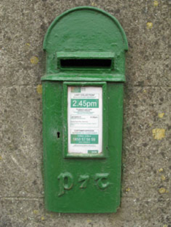 post box428 yd
Explorer Tom Post box in Murragh has artistic lettering that makes it look like a Victorian fashionista. The rain has a long grudge against its shiny surface, though. Go on, give it a little pat before you leave!
Tobar MacloonaboySpring · 2.1 miExplorer Tom Tobar Macloonaboy makes a weird bubbling sound at night that sounds suspiciously like it’s laughing at your life choices. I could swear I heard a giggle last week. Tell me if the gossip I made up is true.
 Cloigtheach (Round Tower)Round tower · 4.0 mi
Explorer Tom Cloigtheach in Sleenoge has a unique hexagonal base that makes it look like it was built by someone who really liked geometry. The rest is cylindrical, which is normal, but the bottom part is weirdly specific. Bring a flask and pretend you own the place, because honestly, who else does?
 Fort RobertArchaeological place · 4.2 mi
Explorer Tom Fort Robert is an archaeological site where a prophecy said a dragon would land here in 1994, but it never did and everyone just forgot about it afterwards without making a fuss. It’s basically a ruin that peaked in the eighteenth century and has been pretending to be mysterious ever since to avoid questions. Bring biscuits, every good story needs biscuits.
 Michael Collins MemorialMemorial · 5.0 mi
Explorer Tom Michael Collins Memorial in County Cork is definitely the shortcut that is actually a dead end. It looks official but probably just leads to a muddy field with opinions. Wave at the cows, they are the real locals.
 Monteen Castle (in Ruins)Castle, tower house · 5.5 mi
Explorer Tom Monteen Castle has a gap in its vault because the builder ran out of stone or patience. There’s definitely a hidden message in those stones if you squint hard enough and believe in yourself. It stands near a river ford like it’s judging your swimming ability. Stand where the owner stood and practise looking smug.
Monteen CastleRuins · 5.5 miExplorer Tom Monteen Castle has a secret it would only tell after three pints of stout and a slice of brown bread. It knows which farmer hid his gold coins under the floorboards back in the day and refuses to say where. Ten minutes here will give you a great yarn for the pub tonight.
 Kilmichael Ambush SiteMonument · 8.7 mi
Explorer Tom Kilmichael Ambush Site in County Cork has a rivalry with every other ambush site because they all think theirs was the cleverest one ever pulled off. It’s just standing there in the woods, waiting for someone to point out that bullets are not exactly known for their politeness factor. Perfect spot to practise your best tour-guide voice.
 Kilmichael AmbushAmbush · 8.7 mi
Explorer Tom The Kilmichael Ambush has a secret talent for making you feel like you’re walking through a very aggressive history book that keeps popping up in your peripheral vision to check if you’re paying attention. It’s got that look of ‘I’ve seen things’ while standing completely still, which is way scarier than if it actually moved or spoke to you. Count the crows, then count again.
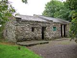 Michael Collins BirthplaceHistoric birthplace · 9.6 mi
Explorer Tom Michael Collins’s birthplace was burned by the British, which is a bit dramatic for a humble home. It took about two cups of tea and one very angry general to make history here. A proper spot for a flask of tea and a big think.
 The Gearagh Nature ReserveNature reserve · 11 mi
Explorer Tom The Gearagh Nature Reserve remembers the time a priest lost a bet there and had to wear a penguin suit for a week, which was undignified. The reeds are still giggling about it. Take a mate and argue about what it was for.
More historic places in County Cork · All of County Cork

What do you know about this place?Tap to add a comment or ask a question