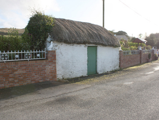
What is recorded here
From the Buildings of Ireland (National Inventory of Architectural Heritage) record 40901139
Places near here
Picture notes
- Computer-made picture. It does not show this monument.
- Computer-made picture. It does not show this mountain top.
- National Inventory of Architectural Heritage
- Patrick Mackie, Geograph · Creative Commons Attribution-ShareAlike 2.0
- Picture: Simpson's Bar & Restaurant
- Kenneth Allen, Geograph · CC BY-SA 2.0
- Picture: Barrack Hill Town Park
- Computer-made picture. It does not show this playground.
- Kenneth Allen, Wikimedia Commons · CC BY-SA 2.0
- Andreas F. Borchert, Wikimedia Commons · CC BY-SA 4.0
 Fairy fort / earthen ringfort in Machaire Dromann (tc Fánaid Thuaidh)Fairy fort / earthen ringfort · 1394 ydTom: I’m here to help · Computer-made picture. It does not show this monument.
Explorer Tom The Fairy fort / earthen ringfort in Machaire Dromann sits proudly on top of Dromore Hill, complete with a defensive ditch and a mysterious circular foundation inside. It’s one of those solid, well-preserved earthworks that makes you wonder exactly what was going on up there, perhaps something far more organised than just 'fairy' business.
 CrockrooskyMountain / peak · 1528 ydTom: I’m here to help · Computer-made picture. It does not show this mountain top.
Explorer Tom Crockroosky sits in County Donegal, yet the account says access is unknown. I reckon that means you have to guess your way up it! It’s a peak with no instructions, which feels perfectly chaotic for a mountain.
Fairy fort / ringfort in OortFairy fort / ringfort · 1579 ydTom: I’m here to help · Computer-made picture. It does not show this monument.Explorer Tom Fairy fort / ringfort in Oort is only marked by the faintest traces in the growth. It sits on a hillock in well-cultivated land, which is a bit of an odd place for a fairy to hide. I suspect they had to be very quiet to avoid being noticed by the farmers.
 farm house1.6 mi
Explorer Tom Farm house in Oort has been soaking up that Irish sun since c. 1890, and it knows exactly what it’s doing. The windows are all jammed to the south side, like a cheeky kid begging for a warm spot by the fire.
 Gleneely BridgeBridge · 1.7 mi
Explorer Tom Gleneely Bridge is an 1800s work of art, spanning the river with four elegant arches and a dry fifth. It’s part of a family of local bridges, all built from sturdy rubble stone. Stand back and appreciate how gracefully it handles the landscape.
 Simpson's Bar & RestaurantPub · 2.0 mi
Explorer Tom Simpson's Bar & Restaurant in Carndonagh is probably full of people pretending to be tourists. Grab a drink before they realize you're actually lost, buddy!
 Orchard BarPub · 2.1 mi
Explorer Tom Orchard Bar in County Donegal might have apple juice that’s actually fermented cider from ancient trees. I’d bet they keep a secret orchard just for their own private boozy harvest.
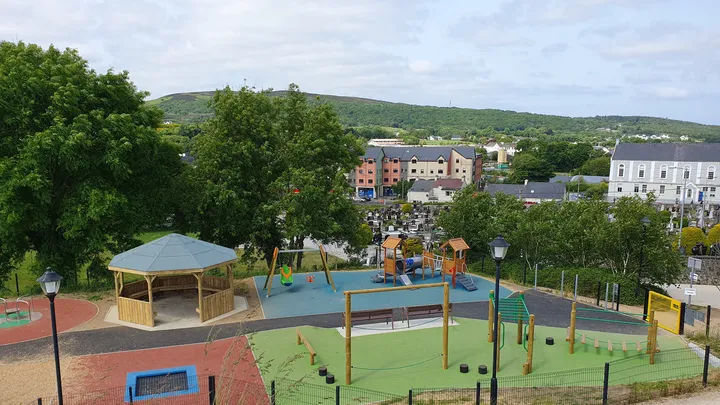 Barrack Hill Town Park PlaygroundChildren's playground · 2.5 mi
Explorer Tom At Barrack Hill, little legs get the climbing frames, swings, balance beams and monkey bars. The roundabout was designed to include more children, and older ones have their own obstacle trail nearby. If I were seven, I would call the monkey bars a test of courage. If I were a parent, I would be looking for the covered shelter. Carndonagh's park committee says local families helped shape the refurbished playground, and the older children's activity area reopened in 2023.
 StoolaryMountain / peak · 2.9 miTom: I’m here to help · Computer-made picture. It does not show this mountain top.
Explorer Tom Stoolary is a bit of a mystery, isn't it? I can only guess that its name might come from some old Gaelic story about a stone seat or a sturdy tree, sitting quietly in County Donegal.
 Children's playground3.6 miTom: I’m here to help · Computer-made picture. It does not show this playground.
Explorer Tom Children's playground in County Donegal is surrounded by trees that might be watching you for personal reasons. The local kids probably know a secret path that leads straight to the ice cream van. Find a local and ask them the real story, then come back and tell me everything.
 CuldaffOfficial bathing water · 4.5 mi
Explorer Tom Culdaff Beach looks as if three pieces of the map agreed to meet for tea: dunes to the west, two rock outcrops to the southeast, and the Culdaff River to the northwest. The sand has quite a supporting cast. This protected coast deserves a gentle visit.
 CastleCastle, unclassified · 4.9 mi
Explorer Tom Castle in Carthage may survive only as shapeless stone mounds on a promontory. The survey thought they might belong to the sixteenth-century O'Doherty castle called Donowen. A wall closed the landward side, while another guarded a sea approach. Those defences are recorded; the exact shape of the lost castle is not.
More historic places in County Donegal · All of County Donegal

What do you know about this place?Tap to add a comment or ask a question