Overview
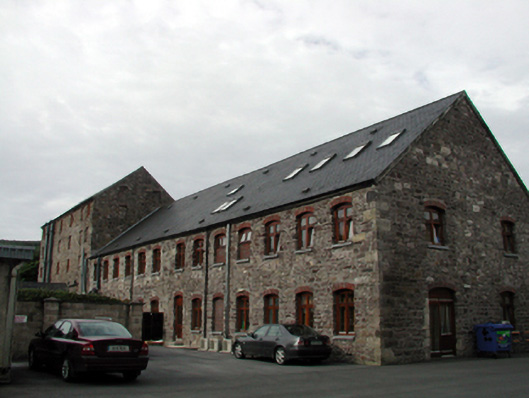
Niervale Mill — Ballymacarbry is recorded as mill (water) in Waterford. Detached ten-bay five-storey rubble stone mill with attic, c.1850. Extended, c.1875, comprising thirteen-bay two-storey rubble stone wing with attic to north-east.
Why it was built
The saved account records: Shallow segmental-headed door openings to wing to north-east with red brick ‘voussoirs’ and replacement glazed timber panelled doors, c.2000, having timber-clad uPVC sidelights and overlights.
People and work
The saved account records: Detached ten-bay five-storey rubble stone mill with attic, c.1850.
How it changed
The saved account records: Extensively renovated, c.2000, with single-bay single-storey projecting glazed porch added to south-east to accommodate use as offices.
What survives
The saved account records: Random rubble stone walls with lime mortar and sections of replacement cement repointing, c.2000.
Why it mattered
Niervale Mill — Ballymacarbry matters for the exact reasons given in its official assessment, rather than merely because it is an old structure. The source records: A well-proportioned, substantial mill building constructed in a traditional manner, which is of particular significance in the locality as a reminder of the development of commercial and industrial activities in Ballymacarbry in the mid nineteenth century. Subsequently converted to accommodate an alternative use, the building retains most of its original form, while replacement fittings do not detract considerably from the historic character of the composition. The mill building remains an important landmark site in the locality and represents a fine example of the identification of a new use for an outmoded… This explains what the place adds to local life, the street or the surviving built history.
History checked 15 August 2026 against the named sources below.
Places near here
- Niervale Mill — Ballmacarbrybuildingunder 0.1 miles
- Niervale Mill — Ballymacarbrybuildingunder 0.1 miles
- house — Ballymacarbrybuildingunder 0.1 miles
- Nirevale — Ballymacarbrybuilding0.2 miles
- Ballymacarbry Garda Síochána Stationbuilding0.2 miles
- Children's playground — County Waterfordattraction0.3 miles
- court house — Ballymacarbrybuilding0.5 miles
- Ballymacarbry Bridge (Old)building0.5 miles
- Kilronan Church — BALLYMACARBRYbuilding0.6 miles
- Hilltop enclosure in Knockatrellanemonument0.6 miles
- Fairy fort / earthen ringfort in Deerpark (glenahiry By.)monument0.7 miles
- Mine in Knockatrellanemonument0.7 miles
Add the human story, a picture, a first-hand message or a missing place.
Earn 5 points after the picture is checked and accepted.
Add a pictureAdd its storyTalk or ask a questionAdd a new placeThis official record and map point do not grant access. Most recorded buildings are privately owned; view them only from public ground unless the owner allows entry.
Conversation about this place
Questions and messages sit beneath the source record. They are checked before appearing.
No questions or messages yet.
Ask a question or join the conversation