Places near here
Photo credits
- kevin higgins, Wikimedia Commons · CC BY-SA 2.0
- National Inventory of Architectural Heritage
- Algirdas at Lithuanian Wikipedia, Wikimedia Commons · Public domain
- AnRo0002, Wikimedia Commons · CC0
- JP, Geograph · CC BY-SA 2.0
- Kieran Campbell, Geograph · Creative Commons Attribution-ShareAlike 2.0
- Kieran Campbell, Wikimedia Commons · CC BY-SA 2.0
Explorer Tom Burial ground in Killeigh sits north of the Parochial House, probably guarding a secret tunnel straight to the pub cellar. The locals swear the ghosts are just thirsty. Mind the nettles, they're the real guards here.
 forge/smithy224 yd
Explorer Tom Forge or smithy in Killeigh is wearing a horseshoe-shaped entrance because apparently that’s how you tell everyone else, 'Hey, I make things hot and shiny.' It’s been modernised, but the original façade still hangs on like a stubborn old dog refusing to let go of its glory days. The carved opening shows off some serious masonry skills that most architects would envy. Look up at
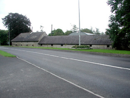 farmyard complex248 yd
Explorer Tom Farmyard complex in Killeigh is on a corner where rabbits have formed a committee about its design. The outbuildings are functional but some bits are falling apart spectacularly. Have a wander and a wonder at the disrepair.
 Mick the MillerMemorial · 282 yd
Explorer Tom Mick the Miller in County Offaly was alive for thirteen years, which means he spent half his life probably arguing with the postman about who had the worse luck. The man must have been a real character if they still remember him by his trade and first name only. It’s an ideal spot to quietly rehearse your best excuse for being late
Scrub HillMountain / peak · 1351 ydExplorer Tom Scrub Hill in County Offaly would describe itself to a stranger as 'a bit rough around the edges but full of character and hidden surprises.' It’s not polished or pretty, but it’s got that raw, untamed energy that makes it interesting to look at for more than five seconds. Look for the ghost, then pretend you didn't.
Red HillMountain / peak · 1.5 miExplorer Tom Red Hill in County Offaly claims to be older than the concept of time itself, which is a bold statement for a hill that looks like a big red bump. It probably just got its name from a rusty fence or some old brickwork, but it won’t admit that, will it? Bring curiosity, leave with a better story than mine.
 Pedunculate Oak3.8 mi
Explorer Tom Pedunculate Oak in County Offaly offers a shortcut that turns out to be a longer walk than taking the main road. This massive tree is blocking your path with such confidence that you’d think it owns the whole county. It’s like trying to rush past a very slow-moving truck on a narrow lane, except this one has leaves instead of mud. Bring someone
 Spindle3.9 mi
Explorer Tom Spindle in County Offaly has a prophecy about it that never came true, mostly because nobody actually checked if it happened. This small tree is all about red berries and smooth bark, looking completely unbothered by the fact that it’s supposed to be magical. It’s like a celebrity who only does one interview a decade and then disappears for years. Bring
 Grand Canal WayWalking route · 4.5 mi
Explorer Tom Grand Canal Way is handling its nosy neighbors by just keeping its eyes on the water, pretending it doesn’t see anyone peering over the railings asking questions. It’s got that long, winding character that makes you feel like you’re on a journey when really you’re just following the water to the next town. Bring your curiosity and leave with a better story
 Graveyard5.7 mi
Explorer Tom Graveyard in Kilbride is locked in a feud with the view over who gets to be photographed first. St Brigid’s well is right there too, so you can drink history and argue about aesthetics simultaneously without breaking a sweat. Hang around long enough and you'll hear a story from a local.
 Ballycowan Castle (in Ruins)Bawn · 6.0 mi
Explorer Tom Ballycowan Bawn in Ballycowan is part of a fortified house built by Sir Jasper Harbert in 1626. It’s got a coat of arms above the doorway, which is very on-brand for the era. The bawn wall provides some serious defensive flair to the whole setup. Pop by and tell it it’s looking well.
Ballycowan CastleCastle · 6.1 miExplorer Tom Ballycowan Castle is where a dance in 1589 went too far and someone dropped their hat. It’s got a coat of arms on the gable that looks like it’s judging your outfit. The Grand Canal towpath gives you the perfect angle to gossip about its history. Tell me if the gossip I made up is true.
More archaeology and monuments in County Offaly · All of County Offaly

What do you know about this place?Tap to add a comment or ask a question