
What is recorded here
From the National Monuments Service (Archaeological Survey of Ireland) record GA017-148
Places near here
Picture notes
- Computer-made picture. It does not show this monument.
- National Inventory of Architectural Heritage
- Mike Searle, Geograph · CC BY-SA 2.0
- Computer-made picture. It does not show this playground.
 Earthwork in CarrowculleenEarthwork · 392 ydComputer-made picture
Explorer Tom Earthwork in Carrowculleen took about three cups of tea to build, maybe four if it rained. Tell your mates you found this mysterious mound first and be done with it.
 Fairy fort / earthen ringfort in PaddockFairy fort / earthen ringfort · 406 ydComputer-made picture
Explorer Tom Paddock’s fairy fort is on the brow of a hill, looking down its nose at you. It has two banks and a fosse, which is just Irish for 'we tried.' Pretend it's yours and plan the housewarming.
 Earthwork in CarrowmunniaghEarthwork · 456 ydComputer-made picture
Explorer Tom Earthwork in Carrowmunniagh looks like someone dumped a hill there and forgot to level it. It took about four cups of tea and one bad decision to build this thing. Wave at the cows, they're the real locals.
 Fairy fort / earthen ringfort in RoyFairy fort / earthen ringfort · 721 ydComputer-made picture
Explorer Tom Fairy fort / earthen ringfort in Roy has been so thoroughly chewed up by field walls it’s basically a abstract art piece. The local sheep probably think it’s a fancy rug. Give it a pat on the way past, it's had a long life.
 Fairy fort / earthen ringfort in CarrowculleenFairy fort / earthen ringfort · 847 ydComputer-made picture
Explorer Tom Fairy fort / earthen ringfort in Carrowculleen is Gannon's Fort, which sounds like a local who missed his rent. It’s D-shaped and looking a bit squashed on the ridge. Stop the car, it’s worth the hazard lights.
 Fairy fort / earthen ringfort in CarrowmunniaghFairy fort / earthen ringfort · 891 ydComputer-made picture
Explorer Tom Fairy fort / earthen ringfort in Carrowmunniagh is close to the summit and known as the Round Fort, which isn't very creative. It has a gap at the south, maybe for letting the wind through. Make a wish, it's had centuries of practice.
 Moated site in CarrowmunniaghMoated site · 948 ydComputer-made picture
Explorer Tom Moated site in Carrowmunniagh is hiding a scandal about who actually dug the moat in the first place. The family has been denying it for centuries, but the mud remembers. Tell the kids it's a castle. Close enough.
 LisduffMoated site · 972 ydComputer-made picture
Explorer Tom Lisduff is playing hide-and-seek with me. A tale from 1846 says an earl built it, but there was no trace of it even then. Get a photo with it before it gets a better agent.
 Moated site in Carrowpadeen WestMoated site · 1018 ydComputer-made picture
Explorer Tom Moated site in Carrowpadeen West is playing hide-and-seek in the mud. It’s basically a rectangle that gave up on being visible, so grab your boots and have a wander and a wonder.
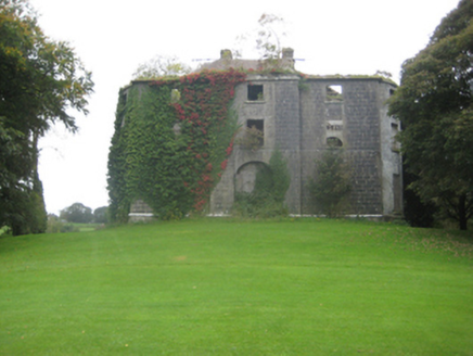 Dunmore HouseCountry house · 1.9 mi
 Country house in Dunmore DemesneCountry house · 1.9 mi
Explorer Tom Country house in Dunmore Demesne is playing hard to get. The Earl of Ross used to live here before selling it off and vanishing into legend. Stand on the spot and imagine the gossip it's heard from the golfers.
 Children's playground2.1 miComputer-made picture
More archaeology and monuments in County Galway · All of County Galway

What do you know about this place?Tap to add a comment or ask a question