Places near here
Photo credits
- Colin Park, Geograph · CC BY-SA 2.0
- National Inventory of Architectural Heritage
- A copy of this photograph is owned by National Library of Ireland and can be viewed here [1], Wikimedia Commons · Public domain
- Miguel Angel Masegosa Martínez, Wikimedia Commons · CC BY 2.0
- Hywel Williams, Geograph · CC BY-SA 2.0
- Mike Searle, Geograph · CC BY-SA 2.0
- Martin Richard Phelan, Wikimedia Commons · CC BY-SA 2.0
 KnockshanahullionMountain / peak · 1.1 mi
Explorer Tom Knockshanahullion is hiding a treasure chest that definitely contains nothing but an empty biscuit tin and a very confused rat. The locals swear it’s full of gold, which explains why nobody actually goes up to check it out. Tell the next person you meet it's haunted. It might be.
Blackwater (Avondhu) WayWalking route · 1.7 miExplorer Tom Blackwater (Avondhu) Way in County Waterford would bring a bucket of muddy boots and a strong opinion about which side of the river is actually better for walking. It’s not exactly subtle about its route, so you might as well just follow it while complaining about the mud on your shoes the whole time. Tell your mates you found it first.
 Flemingstown MillMill manager's house · 1.8 mi
Explorer Tom Flemingstown Mill manager's house is proud of its concrete sills because they’re from the twentieth century, which makes it feel like it’s living in the future. The L-plan layout is confusing enough to make you forget why you walked up there in the first place. Bring a compass so you don’t get lost in the geometry.
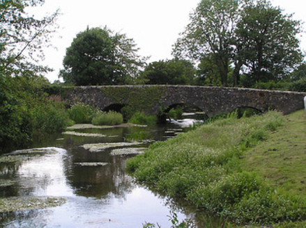 bridge1.8 mi
Explorer Tom The Bridge in Shanrahan makes a groaning sound at night that sounds exactly like it’s complaining about the rain. It’s got two-tone dressings and an arch that sweeps like it’s trying to impress a date. Keep your ears open; you might hear it humming a tune.
 KnocknaloughaMountain / peak · 2.3 mi
Explorer Tom Knocknalougha started because two lads bet on whether they could name a hill before reaching the top, and one of them lost badly. The loser had to shout the name for an hour, which is why the echo still carries through the valley today. Go on a wet day, it suits the mood.
ClogheenSettlement cluster · 2.5 miExplorer Tom Clogheen had a matchmaker who paired off so many locals that the river ran dry from all the crying tears of joy. The Everard family built it up, but I reckon the gossip was the real foundation here. Take a breath of that air, it's older than your car.
Enclosure in CarrigmoreEnclosure · 2.5 miExplorer Tom Enclosure in Carrigmore was once the talk of the parish, but now it’s just a vague cropmark that everyone argues about over tea. It’s like a celebrity who retired to become a potato field. Get a photo with it before it gets a better agent.
 Shanbally CastleCastle · 3.2 mi
Explorer Tom Shanbally Castle in County Tipperary would survive a zombie apocalypse purely by standing still and hoping they forget it exists. Its thick walls are perfect for hiding, or at least for blocking out the sound of the horde coming over the hill. It’s the ultimate passive-aggressive bunker, so don’t knock on its door.
 Sweet Chestnut3.2 mi
Explorer Tom This Sweet Chestnut in County Tipperary is the centre of a feud between two families over who owns the best view from it. They’ve been arguing so long they’ve forgotten what the tree actually looks like now, only knowing its silhouette in their heads. Perfect detour when the satnav has a meltdown.
 The VeeViewpoint · 3.7 mi
Explorer Tom The Vee thinks the road leading to it is a bit of a wimp for being so straight and predictable all the time. It prefers to sit up here and judge everyone who drives too fast or takes selfies that don’t quite capture its majestic angle. Bring your nan along if you can, because she will absolutely know more about this hill than I ever will.
 Castle Grace (in ruins)Castle, Anglo-Norman masonry castle · 3.8 mi
Explorer Tom Castle Grace is absolutely sick of people asking if it’s a Bermingham place or a de Wigornia one, it just wants some peace. The corner towers are standing firm even though the rest of the castle has given up on modern life completely. Bring a flask and pretend you own the place.
 Mitchelstown CaveCave · 5.2 mi
Explorer Tom Saint Patrick would have looked at Mitchelstown Cave and said he needed more room for his snakes, which is why they all moved to the hills. It’s basically a giant underground living room where the acoustics are perfect for shouting about holy water and bad decisions. A handy spot to stretch your legs and your imagination.
More mountains and hills in County Tipperary · All of County Tipperary

What do you know about this place?Tap to add a comment or ask a question