
What is recorded here
The Mill at Carrickaslane retired with three sets of grinding stones and the gearing still in place. Don’t go near it carrying grain; that’s how you get trapped by a retired man who says, ‘I’ll just show you one thing.’
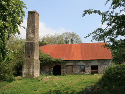
Water-powered mill complex, built c.1800, comprising former corn mill and kiln, flax mill, now disused, and miller's house. Four-bay three-storey water-powered corn mill and kiln, aligned east-west, on east side of mill race, mill occupies western three bays, kiln occupies easternmost bay. Pitched natural slate roof, with raised verge between mill and kiln and clay ridge tiles. Random rubble walls with advanced brick eaves course and squared stone quoins. Square-headed openings with brick block-and-start surrounds, no sills to window openings. Original windows to south elevation comprising six-over-three pane timber sliding sash frames, having bars to ground floor, and replacement timber windows to east elevation. External water-wheel on west gable with wrought-iron paddles and high breast-shot water feed. Three sets of mill stones to interior of first floor of mill, one for shelling and two for grinding. Four-bay two-storey former water-powered flax mill aligned east-west north of the corn mill, abutted to south by modern agricultural building. Pitched corrugated-iron roof, random rubble walls, having square-headed openings with brick block-and-start surrounds, no sills to windows. One window opening blocked up with red brick. No remaining original fittings. Water-wheel to west gable no longer present. Three-bay single-storey former miller's house with attic on east side of complex, having pitched natural slate roof with brick chimneystacks and painted rendered walls, still inhabited. Located west of country road and former Carrickaslane national school.
Although disused since the mid-twentieth century, the corn and flax mill at Carrickaslane represent a good example of a medium-sized early-nineteenth century mill complex, and is of technical interest due to the survival of waterworks, plant, power transmission gearing and machinery in the corn mill. The complex is also of historical interest by having both corn and flax mills at the one site, and has an important group value with the mill house to the east. A corn mill and a flax mill are both named on the 1835 and 1908 Ordnance Survey maps. The Griffith Valuation c.1858 describes the premises as 'flax mill, corn mill, scutcher's house', operated by Viscount Templetown. Viscount Templetown, of the Upton family, had a large stake in the Blayney Estate, owning much of the northern Parish of Muckno, in which Carrickaslane lies. The family also had a large model farm at Corratanty, close by to the south-east, and would have had a vested interest in maintaining a high standard of processing mills in the area. The corn and flax mills played a key role in the economic prosperity of the area, in particular its role as a corn mill during and after the Great Famine. The building also serves as a reminder of past industrial processes, and represents an integral element of the industrial heritage of rural Monaghan, which had a high proportion of grain and flax mills due to the strength of agricultural activities in the county. This fine and imposing mill, now disused, took advantage of its hillside location and fall of water to power a mill wheel, which in turn would have powered the mechanism to grind corn. The site maintains some physical remnants of its former use such as a mill race and mill pond to the north-west leading from Carrickaslane Lough. The raised roof verge between the kiln and mill is indicative of nineteenth-century fire-shielding, and highlights the planning and forethought which went into the buildings' original construction. The visually pleasing contrast of red brick and rubble stone elements in the walls, coupled with the overall mass and height of the complex, makes this series of buildings a significant part of the region's historic landscape.
From the Buildings of Ireland (National Inventory of Architectural Heritage) record 41402002
This does not grant access. Most recorded buildings are privately owned; view them only from public ground unless the owner allows entry.
Places near here
Photo credits
- National Inventory of Architectural Heritage
- Dean Molyneaux, Wikimedia Commons · CC BY-SA 2.0
- Kenneth Allen, Geograph · CC BY-SA 2.0
- Shane Killen, Wikimedia Commons · CC BY-SA 2.0
- Eric Jones, Geograph · CC BY-SA 2.0
- Wanfried-Dublin, Wikimedia Commons · CC BY 4.0
- James O'Neill, Wikimedia Commons · CC BY-SA 4.0
 mill (water)354 yd
 bridge1498 ydJohn Francis GreenMemorial · 2.0 miMonaghan WayWalking route · 2.1 mi
 Blaney CastleCastle · 2.7 mi
 Monaghan WayWalking route · 2.9 mi
 Lough MucknoLake and park landscape · 3.2 mi
 MullavashPassage tomb · 3.9 mi
 Mullyash MountainMountain / peak · 3.9 mi
 Portal tomb in LennanPortal tomb · 4.1 mi
 Crane IslandIsland · 4.1 mi
 Battle of ClontibretBattlefield · 4.9 mi
More historic places in County Monaghan · All of County Monaghan
What do you know about this place?